
To help Council Candidates and Voters better understand cycling policy and infrastructure project priorities, Bike Winnipeg has put together a number of policy and infrastructure recommendations that we hope can be moved forward in the next term of council.
Local Priorities for Walking and Biking
Arlington Bridge and Protected Bike Lanes
The Arlington Bridge is nearing the end of its life and must be replaced. A plan for replacement of the bridge and installation of protected bike lanes between McDermot Avenue and Selkirk Avenue has been developed over the last 4 years through an extensive public engagement process. The expected completion date for replacement of the bridge and associated work on Arlington would be 2023 or 2024, but only if funding for detailed design and construction is approved. The latest estimate for the cost of the bridge is $330 million, however no construction funding is currently approved.

Plans for a new Arlington Bridge will include protected bike lanes between McDermot Avenue and Selkirk Avenue. Although the bridge is at the end of its usable life, funding for bridges replacement has not been approved.

Plans for the replacement of the Arlington Bridge include protected bike lanes that will run from McDermot Avenue to Selkirk Avenue.
Extending Protected Bike Lanes to Portage and Inkster
To fully capitalize on the investment being put into the Arlington Bridge replacement and its accompanying protected bike lanes, those bike lanes need to be extended south to Portage Avenue (with further improvements south to Westminster or Wolseley) and north to Inkster Boulevard.

Cycling potential along Arlington Street

Arlington transects some of the city’s most disadvantaged neighourhoods
Arlington intersects all of the major east/west bikeways in the northwest quadrant of the city, running through sections of the city with the highest potential for cycling and some of the city’s least advantaged neighbourhoods. Arlington’s potential to encourage new bike trips and improve people’s well-being is likely unsurpassed in Winnipeg.
Arlington is scheduled for a major rehabilitation between Notre Dame and William in 2022 at a cost of $5 million. To make sure that this rehabilitation includes the protected bike lanes that Arlington calls out for, a preliminary study should be initiated by 2020 at the latest to give enough time to allow for proper public engagement, detailed design, and purchase of any surface parking that may be required to provide protected bike lanes throughout Arlington’s length.
More Information
A Better Bridge for Arlington (City of Winnipeg)
Completion of the Northwest Hydro Corridor Greenway to Jarvis Ave
The Northwest Hydro Corridor Greenway will be constructed as a separated bicycle and pedestrians pathway along a hydro right of way running parallel to McPhillips Street from just north of the McPhilips Street Casino to the Seven Oaks Hospital and beyond. Te Northwest Hydro Corridor Greenway will eventually extend to the future Chief Peguis Trail and Precinct G, and ultimately north across the Perimeter Highway.

The Northwest Hydro Corridor Greenway has potential similar to that of the Bishop Grandin Greenway
A Northwest version of the Bishop Grandin Greenway?
Serving an area that has very few roadways with cycling specific infrastructure, the Northwest Hydro Corridor Greenway is envisioned as a major spine in the City’s planned cycling network. Much like the Bishop Grandin Greenway in the south end of the city, the Northwest Hydro Corridor Greenway has the potential to offer cyclists a route substantially removed from traffic.
Over $1 million has been allocated for design and construction of the Northwest Hydro Corridor Greenway to date. Construction work on the greenway should begin in 2019, starting from it’s northern end near the Seven Oaks Hospital.
Candidates Asked to Commit to Completion to Jarvis Avenue by 2022
We are calling on all candidates in Mynarski, Old Kildonan, and Point Douglas to commit to completion of the Northwest Hydro Corridor Greenway to Jarvis Avenue by the end of their first term in office in 2022.
In addition, we are calling on all candidates to commit to demand that any extension of the Chief Peguis Trail (CPT) west will include planing for a future grade separation over the CPT along Northwest Hydro Corridor Greenway, and to ensure that its construction is included in any developer agreements related to Precinct D.
- Reserve/Acquire necessary property for construction of a Pedestrian & Cycling bridge
- The Northwest Hydro Corridor Greenway is proposed as an off road spine in the city’s bike network, and will provide connectivity between Precinct D, Seven Oaks Hospital, the McPhillips & Leila Regional Mixed Used Centre, and the Downtown.
- The importance of this crossing in the pedestrian and bicycle networks matches the importance of arterial streets which are routinely included in developer agreements.

The Northwest Hydro Corridor is identified as a high quality network spine in the Pedestrian and Cycling Strategies
Northwest Hydro Corridor Greenway Highlights:
- Creates a cycling connection into the northwest of the city
- Currently under served in terms of cycling routes
- Long term plans include a cycling crossing of the CPR main line
- Excellent connectivity with existing and planned east/west cycling routes
- Chief Peguis Trail Pathways
- Kingsbury Avenue
- Jefferson Avenue
- Church/Machray Avenues
- Pritchard Avenue
- Alexander/Pacfic/Elgin Avenues (Health Science Centre Complex & both Red River College Campuses
- Potential to Connect/Extend North/South Routes
- Empress Street Pathway
- Winnipeg Beach Greenway
- Connects to Many High Value Destinations
More Information
- Bike Winnipeg Discussion Paper:
— Northwest Hydro Corridor Greenway Discussion Paper (9MB pdf)
— low resolution version (1MB pdf) - 2018 Pedestrian and Cycling Program Action Plan (pdf)
- Chief Peguis Trail Extension Project (City of Winnipeg)
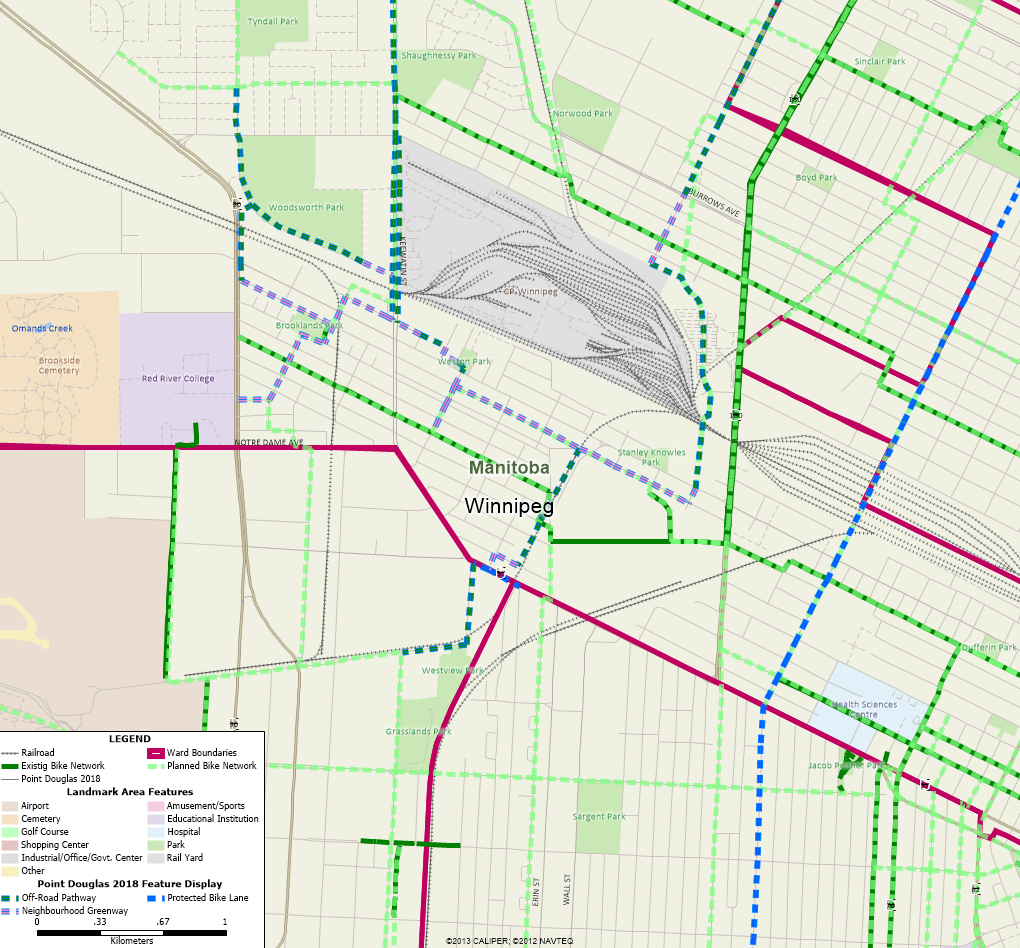
Keewatin Street Underpass & Pathway (East & West sides)
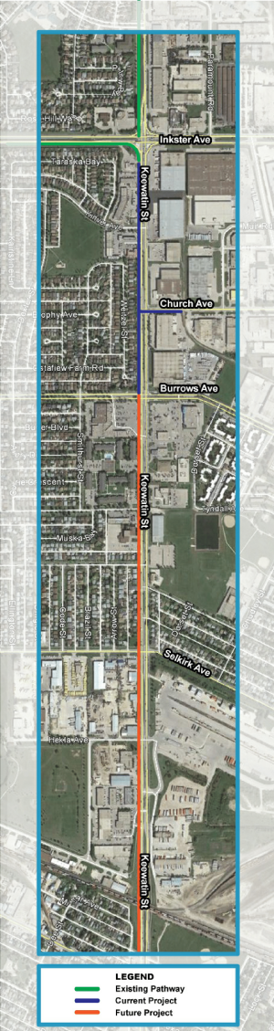
Functional Design work for an extension of the Keewatin St Pathway south to Gallagher Ave is scheduled for 2019.
In 2018, an off-street pathway was built along Keewatin Street from Burrows Avenue to Inkster Boulevard. This pathway connects with existing off-street pathways on:
- Keewatin Street/Dr. Jose Rizal Way from Inkster Boulevard to Water Ridge Path, and
- Inkster Boulevard between Inksbrook Drive and Keewatin Street.
In addition, the Keewatin Street Pathway connects to the bike lanes on Church Avenue, where a new traffic signal has been installed to help facilitate safe crossings of Keewatin Street.
Once extended under the CPR Mainline to Gallagher Avenue, the Keewatin Street Pathways will provide connections to Red River College’s Notre Dame Campus, the Health Science Centre Complex, and the Weston Memorial Community Centre. Future extensions to the Empress Street Pathway will eventually provide a connection to the Polo Park area. However, the western connections to the Health Sciences Complex, Weston Memorial Community Club, and Polo Park will only be realized if pathways are built on both the east and west sides of Keewatin Street south of Selkirk Avenue as there are no safe crossings of Keewatin Street south of Selkirk Avenue and no plans to extend the pathway beyond Gallagher Avenue.
Current plans only include a pathway on the west side of Keewatin Street.
Keewatin Street Pathway Study Needs to Consider Connectivity East of Keewatin Street
The 2018 Pedestrian and Cycling Program Action Plan forecasts spending of $300,000 in 2019 for a study to extend the Keewatin Street Pathway from Burrows Avenue to Gallagher Avenue. The remaining sections of pathway will be completed around 2021 at the same time as the road renewal on Keewatin Street between Selkirk Avenue and Logan Avenue. The cost for the roadway rehabilitation is estimated to be $3.1 million, while its estimated that an additional $2 million (currently unfunded) will be needed for construction of the the Keewatin Street Underpass Cycling Facility.
To provide the best value for our tax dollars, and to provide much needed connections to the east of Keewatin Street, we are asking that the 2019 Functional Design Study and subsequent construction project for the Keewatin Street Pathway include the following:
- Pathways on both sides of Keewatin Street south of Selkirk Ave.
- CP should be approached about property acquisition along Keewatin and Selkirk Avenue to provide space for the pathways.
- Neighbourhood Greenway connections on the west to Red River College’s Notre Dame Campus.
- Neighbourhood Greenway connections to Worth Street at Alexander Avenue to provide connections to:
- Weston Memorial Community Centre
- Health Science Centre Complex
- The Polo Park area (via a future extension of the Empress Street Pathway)
- A Pathway Connection on the south side of Selkirk Avenue from Keewatin to Chudley Street.
- Would require property acquisition from CP to provide space for the pathway, which could ultimately be extended to the Northwest Hydro Corridor Greenway and the McPhillips Street at Jarvis Avenue intersection if property could be acquired from CP.
Connection to Park Lane
On the north side of the tracks, it will be important to ensure that the pathway on the west side of Keewatin Street connects to Park Lane Avenue. Park Lane Avenue provides access to Woodsworth Park, and more importantly to King Edward Street and Tyndall Park.
More Information
- Keewatin Street Pathway Project (City of Winnipeg)
Burrows Central-Shaughnessy Park-Tyndall Park Corridor Study
Providing neighbourhood connections to major destinations such as schools, recreation centres, parks, libraries and shopping is one of the goals of the city’s Pedestrian and Cycling Strategies (see Direction 1B – Action Item 10)[1].
The Burrows Central-Shaughnessy Park-Tyndall Park Neighbourhood Greenway that we are proposing would run from Egesz Street in Tyndall Park to Arlington Street in the Burrows Central neighbourhood. Along the way it would pass through the Shaughnessy Park and Burrows-Keewatin neighbourhoods as well.
Essentially, the Burrows Central-Shaughnessy Park-Tyndall Park Neighbourhood Greenway would follow a routing along Charter Dr, Marble Ave, Herman Ave, Tyndall Ave, Gilbert Ave, and Redwood Ave. Mixed traffic would remain on these roadways (with minimal traffic calming measures needed to keep traffic levels low), but crossings at major intersections like Keewatin and Burrows would be improved to improve safety and comfort levels, and some short segments of pathway would be added (or upgraded) to connect the chosen route.
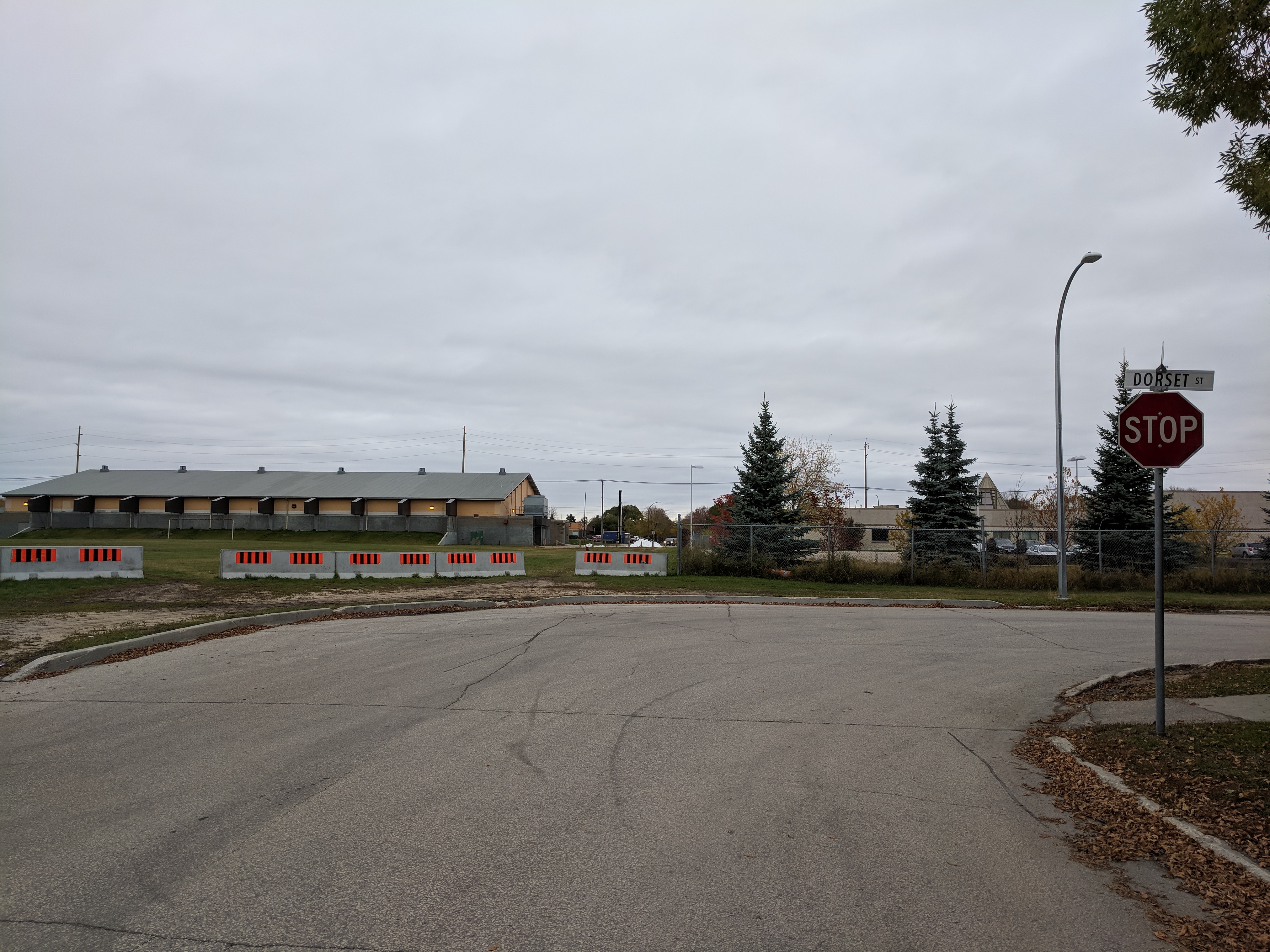
A connection between Tyndall Avenue and Tyndall Park could be provided with installation of a traffic signal to aid the crossing of Keewatin Street and a pathway between Dorset St and Keewatin St just north of the Billy Mosienko Arena
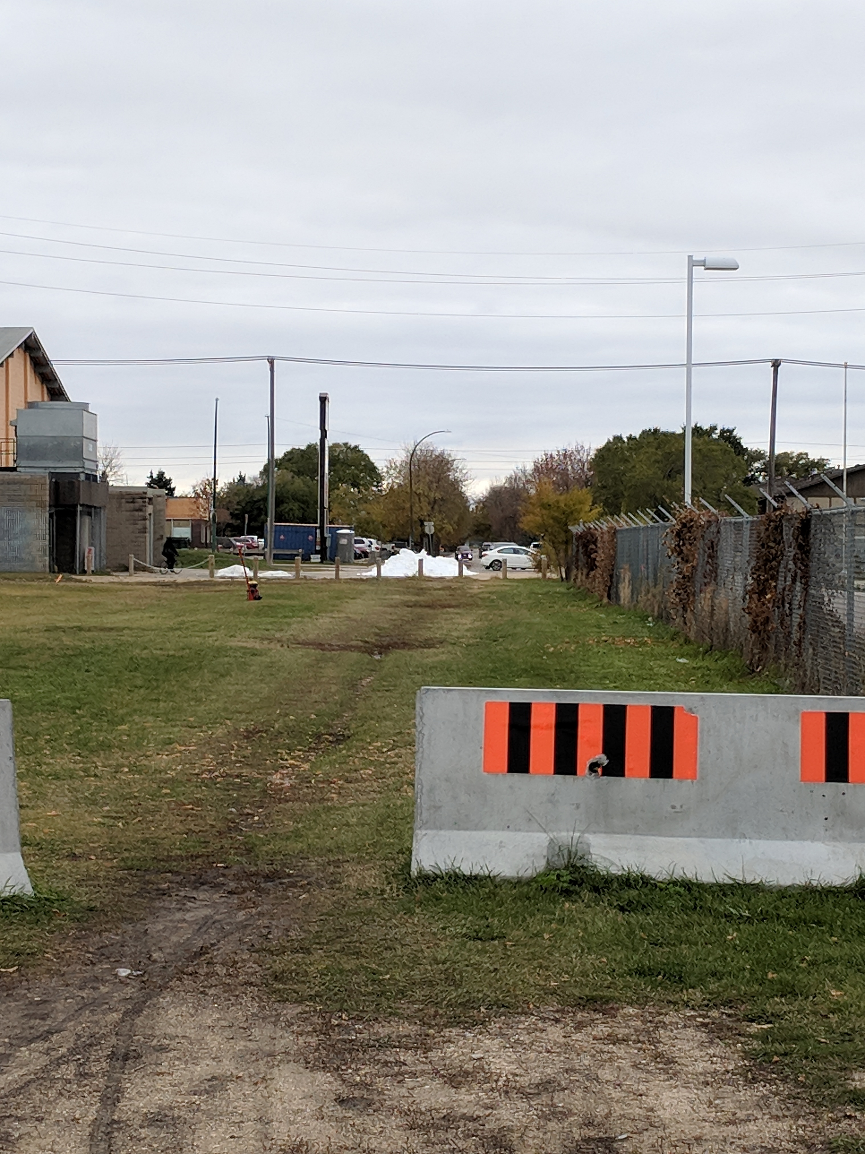
A pathway from Dorset Ave to Keewatin St combined with installation of a traffic signal at Keewatin St would provide access between Shaughnessy Park and areas west of Keewatin St.
Key destinations along the route we are proposing would include:
- Tyndall Park Community Centre
- Tyndall Park Community School
- Tyndall Market (Shopping)
- Tyndall Square (Shopping)
- Shaughnessy Park (Soccer & Baseball Fields)
- Sir William Stephenson Library
- Philippine Canadian Centre of Manitoba (PCCM),
- Billy Mosienko Arena
- Shaughnessy Park School
- Shaughnessy Recreation Centre
- Northwood Park
- Northwood Park Community Centre
- Sisler High School
- Lord Nelson School
Existing pathways in Shaughnessy Park provide access from Dorset Ave to Gilbert Ave.
Easy access to the following destinations would also be provided:
- McPhillips Street Casino (via Northwest Hydro Corridor Greenway)
- Old Exhibition Grounds Park (via a Neighbourhood Greenway on Battery St)
- Old Exhibition Arena (via a Neighbourhood Greenway on Battery St)
- Sergeant Tommy Prince Place (formerly North Centennial Recreation & Leisure Facility) (via a Neighbourhood Greenway on Battery St)
- The Centennial Swimming Pool (via a Neighbourhood Greenway on Battery St)
- Winnipeg Aboriginal Sport Achievement Centre (via a Neighbourhood Greenway on Battery St)
The proposed Burrows Central-Shaughnessy Park-Tyndall Park Neighbourhood Greenway compliments bicycle network improvements currently underway on the following projects (all of which should be completed within the next 5 years):
- Keewatin Street Underpass & Pathway Extension
- Northwest Hydro Corridor Greenway
- Arlington Bridge & Protected Bike Lanes
The section connecting Gilbert Avenue to Redwood Avenue will be the most challenging part of the bikeway to develop (crossings of Burrows Avenue, the CPR Arborg Line, and Sheppard St), but alternatives to a direct route exist and can be considered as part of the design.
East of the CPR Arborg Rail Line, the Burrows Central-Shaughnessy Park-Tyndall Park Neighbourhood Greenway would replace Burrows Avenue in the planned bike network, as the feasibility of converting Burrows Avenue into a neighbourhood greenway (or adding bike lanes) between Keewatin and Main Street is untenable (limited right of way and lane widths, mature trees on a narrow median, high demand for parking, high volumes of traffic).
Plans for a neighbourhood greenway, bike path, or bike lanes along Burrows Ave are likely untenable.
Plans for a neighbourhood greenway, bike path, or bike lanes along Burrows Ave are likely untenable.
Together with a pathway on the south side of Selkirk Avenue between Keewatin St and McPhillips St it would also replace the Manitoba Avenue Neighbourhood Greenway as it would provide better connectivity to destinations, better crossings, and fits in better with the desired mesh width of the cycling network.
We would like to see candidates commit to including a corridor study for this route in the 2019 or 2020 Pedestrian and Cycling Program Action Plan, with construction to follow in 2021 and 2022.
Full cost of studies plus improvements would likely be around $3 million.
End Notes
[1] Pedestrian and Cycling Strategies – Direction 1B – Action Item 10; Page 291, City of Winnipeg, 2015
Ensure that bicycle requirements be addressed in all new and renewal road projects that are part of the bicycle network or where the road provides connectivity or support to the bicycle network.
Improved Connectivity to Red River College Notre Dame Campus
The current cycling connections to Red River College’s Notre Dame Campus are via the Sherwin Road Pathway on the south side of the campus and the Alexander-Pacific-Elgin Neighbourhood Greenway to the east. Both bikeways were developed prior to adoption of the Pedestrian and Cycling Strategies in 2015 as part of the 2009-2010 Federal Stimulus package.
A new connection along Keewatin Street is currently being developed. In 2018, the pathway along Keewatin Street/Dr. Jose Rizal Way was extended south to Burrows Avenue. Plans for extension of the Keewatin Pathway south through the Keewatin Underpass to Gallagher Ave. will be developed in a functional design study scheduled for 2019. Construction is currently scheduled for 2021 at the same time as a planned road renewal project on Keewatin Street between Selkirk Avenue and Logan Avenue. A neighbourhood greenway along Gallagher Ave, Dee St, Pacific Ave., and Oddy St. would provide connections from the southern end of the pathway at Gallagher Ave. to Red River College’s Notre Dame Campus. The Gallagher-Dee-Pacific-Oddy Neighbourhood Greenway is identified in the Pedestrian and Cycling Strategies.
Completing the Alexander-Pacific-Elgin Neighbourhood Greenway
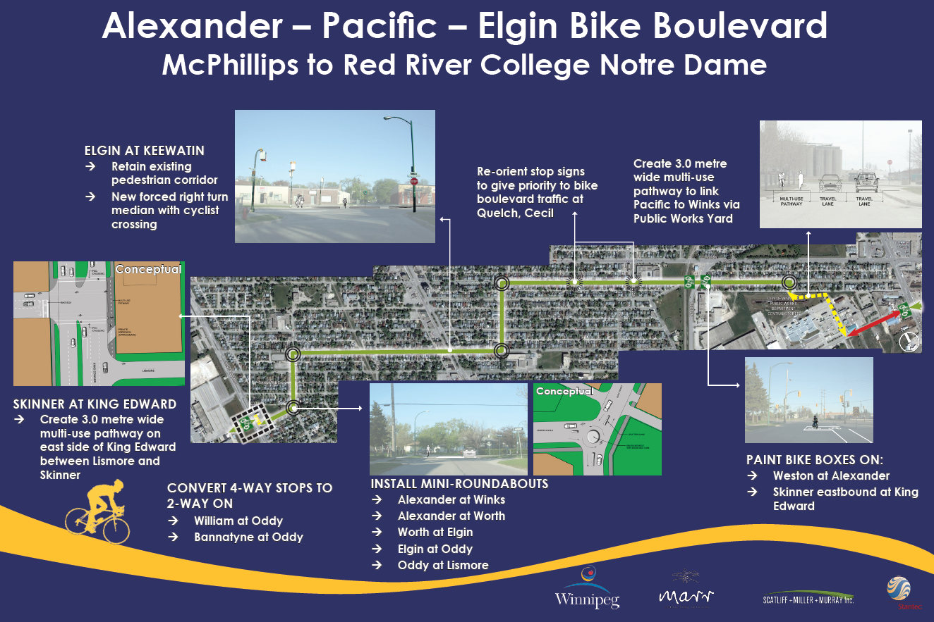
Many of the planned improvements for the Alexander-Pacific-Elgin Neighbourhood Greenway connecting to Red River College have never been completed.
Although plans for the Alexander-Pacific-Elgin Neighbourhood Greenway show several improvements to provide a connection to Red River College via Oddy St., Lismore Ave., and Skinner Rd, other than occasional signage none of the planned improvements along this part of the route were ever built. As the planned Keewatin Street Pathway will provide an obvious connection to Red River College’s Notre Dame Campus, we feel it makes sense to include improvements to the existing Alexander-Pacific-Elgin Neighbourhood Greenway in the Keewatin Street Pathway – Burrows to Gallagher Ave W Functional Design Study, currently scheduled for 2019.
We ask that all candidates in Point Douglas and Old Kildonan commit to the inclusion of construction of the Gallagher-Dee-Pacific-Oddy Neighbourhood Greenway in plans for the road renewal project on Keewatin Street between Selkirk Avenue and Logan Avenue scheduled for 2021.
Keewatin Street Crossing
Crossing of Keewatin Street along the Alexander-Pacific-Elgin Neighbourhood Greenway is currently aided by a pedestrian corridor, but unfortunately development of the greenway back in 2009.2010 did not include a way for someone on a bike to activate that pedestrian corridor (you have to get up onto the Notre Dame sidewalk to reach the crosswalk – which is offset by a fair bit on the east side of Keewatin Street- and activate the signal). This intersection crossing could be vastly improved through the installation of cyclist activated push buttons on Elgin Ave for activation of the pedestrian corridor and signage requiring northbound drivers on Keewatin Street to stop prior to Elgin Ave. when the pedestrian corridor is activated.
We are asking candidates in Point Douglas, St. James, and Daniel McIntyre to commit to including improvements to the Elgin AVe/Keewatin Street crossing in the Keewatin Street Pathway – Burrows to Gallagher Ave W Functional Design Study and any subsequent construction projects.
Plan & Construct the Gallagher-Dee-Pacific-Oddy Neighbourhood Greenway
Completion of the Keewatin Street Pathway through the Keewatin Street Underpass to Gallagher Ave W. will remove a major barrier for people wishing to bike to the Notre Dame Campus from the city’s northwest. The planned Gallagher-Dee-Pacific-Oddy Neighbourhood Greenway will act as the obvious connection between the two, but it’s planning and development is not currently included in the city’s Pedestrian and Cycling Program plans.
We are asking all candidates in Point Douglas and Old Kildonan to commit to the planning of the Gallagher-Dee-Pacific-Oddy Neighbourhood Greenway in the Keewatin Street Pathway – Burrows to Gallagher Ave W Functional Design Study, currently scheduled for 2019. We would also ask that candidates commit to including construction of the Gallagher-Dee-Pacific-Oddy Neighbourhood Greenway in plans for the road renewal project on Keewatin Street between Selkirk Avenue and Logan Avenue scheduled for 2021.
Improve Connections into RRC from the Sherwin Rd Pathway
The Sherwin Road Pathway makes use of a Pedestrian Corridor to facilitate crossings at Notre Dame Avenue, but the Pedestrian Corridor is located across the street from the pathway, which is on the west side of Sherwin Rd). Shared use pathways on Notre Dame provide a connection from Sherwin Rd to Dalton Crescent, but the connection is one way, and as it necessitates a crossing of Sherwin Rd. to cross Notre Dame Avenue, its a bit awkward.
We are asking candidates to commit to a long term plan to provide connections from Sherwin Rd to:
- Lismore Ave and the Alexander-Pacific-Elgin Neighbourhood Greenway
- Bannister Rd
- King Edward Street at Logan Avenue as a connection to the King Edward Street Pathway.
Planning for Future Connections to the King Edward Underpass & Bikeway
The bicycle network laid out in the 2015 Pedestrian and Cycling Strategies shows a local bikeway along King Edward Street beginning at Manitoba Ave. and running north to Jefferson Ave where it would connect to pathways planned along Jefferson and the planned extension of the Chief Peguis Trail. While the planned bike network does not include a connection through the King Edward Street Underpass, given that Keewatin Street and its pathway are 800m east of King Edward St, it seems obvious that this connection will eventually be needed. The 800m gap between King Edward and Keewatin Streets exceeds the maximum recommended distance between cycling facilities outside of the downtown (see page 135 of the Pedestrian and Cycling Strategies), so an extension of the King Edward Street Pathway south through the King Edward Street Underpass fits in with the strategies key directions 1B.i, 1B.vi, and 1B.xi of the Pedestrian and Cycling Strategies.
Extending the King Edward St Pathway south to Alexander would provide direct access between:
- Jefferson, Chief Peguis, and Sherwin Rd Pathways
- Red River College Notre Dame Campus
- Edon Ross Pool
- Brooklands School
- Woodsworth Park
- Tyndall Park Community Centre
- Tyndall Park Community School
- Brooklands, Tyndall Park, Garden Grove, Meadows West, Inkster Gardens, Waterford Green, Castlebury Meadows Neighbourhoods
Interim steps would be to:
- Formally adopt an extension of the King Edward Street Pathway south from Manitoba Avenue to Alexander Avenue in the city’s planned Bicycle Network.
- Formally adopt an extension of the King Edward Street Pathway west to the Keewatin Street Pathway through Woodsworth Park and Park lane in the city’s planned Bicycle Network.
Summary of Requested Candidate Commitments
- Include Planning for the Alexander-Pacific-Elgin and Gallagher-Dee-Pacific-Oddy Neighbourhood Greenways in the 2019 Keewatin Street Pathway – Burrows to Gallagher Ave W Functional Design Study.
- Commit to including improvements to the Elgin AVe/Keewatin Street crossing in the Keewatin Street Pathway – Burrows to Gallagher Ave W Functional Design Study and any subsequent construction projects.
- Commit to a long term plan to provide connections from Sherwin Rd to:
- Lismore Ave and the Alexander-Pacific-Elgin Neighbourhood Greenway
- Bannister Rd
- King Edward Street at Logan Avenue as a connection to the King Edward Street Pathway.
- Formally adopt an extension of the King Edward Street Pathway south from Manitoba Avenue to Alexander Avenue in the city’s planned Bicycle Network.
- Formally adopt an extension of the King Edward Street Pathway west to the Keewatin Street Pathway through Woodsworth Park and Park lane in the city’s planned Bicycle Network.
More Information
- 2009 Alexander-Pacific-Elgin Neighbourhood Greenway Plans (pdf)
- Keewatin Street Pathway (City of Winnipeg)
- Bike Winnipeg Backgrounder on Keewatin Street Pathway
- Empress Street Overpass Rehab & Reconstruction (City of Winnipeg)
- 2018 Pedestrian and Cycling Program Action Plan (City of Winnipeg)
Empress Street Pathway Connections
A pathway along the east side of Empress Street will be built in 2019 as part of the Empress Street and Overpass Reconstruction and Rehabilitation Project, extending from St. Matthews Avenue in the north south over the Empress Street Overpass to the North Assiniboine Parkway. Future plans call for the pathway to be extended north all the way to Saskatchewan Avenue, where it will connect to pathways along Saskatchewan Avenue and Sherwin Road to provide a connection to Red River College’s Notre Dame Campus.
What’s missing from the planning to date is a way to connect from this planned Empress Street pathway north to the Alexander-Pacific-Elgin Neigbhourhood Greenway and the Northwest Hydro Corridor Greenway, and northwest towards the Keewatin Street Pathway. Work to extend the Keewatin Pathway south to Gallagher Avenue is scheduled to take place in 2019 (see our recommendations and rationale to include a path on the east side of Keewatin along with the planned pathway on the west side of Keewatin). Work on the Northwest Hydro Corridor Greenway should begin in 2019 (although an extension across the CPR Mainline may need to wait for a rehabilitation of the McPhillips Street Underpass).
An All Ages & Abilities Connection from Empress St to Alexander Ave
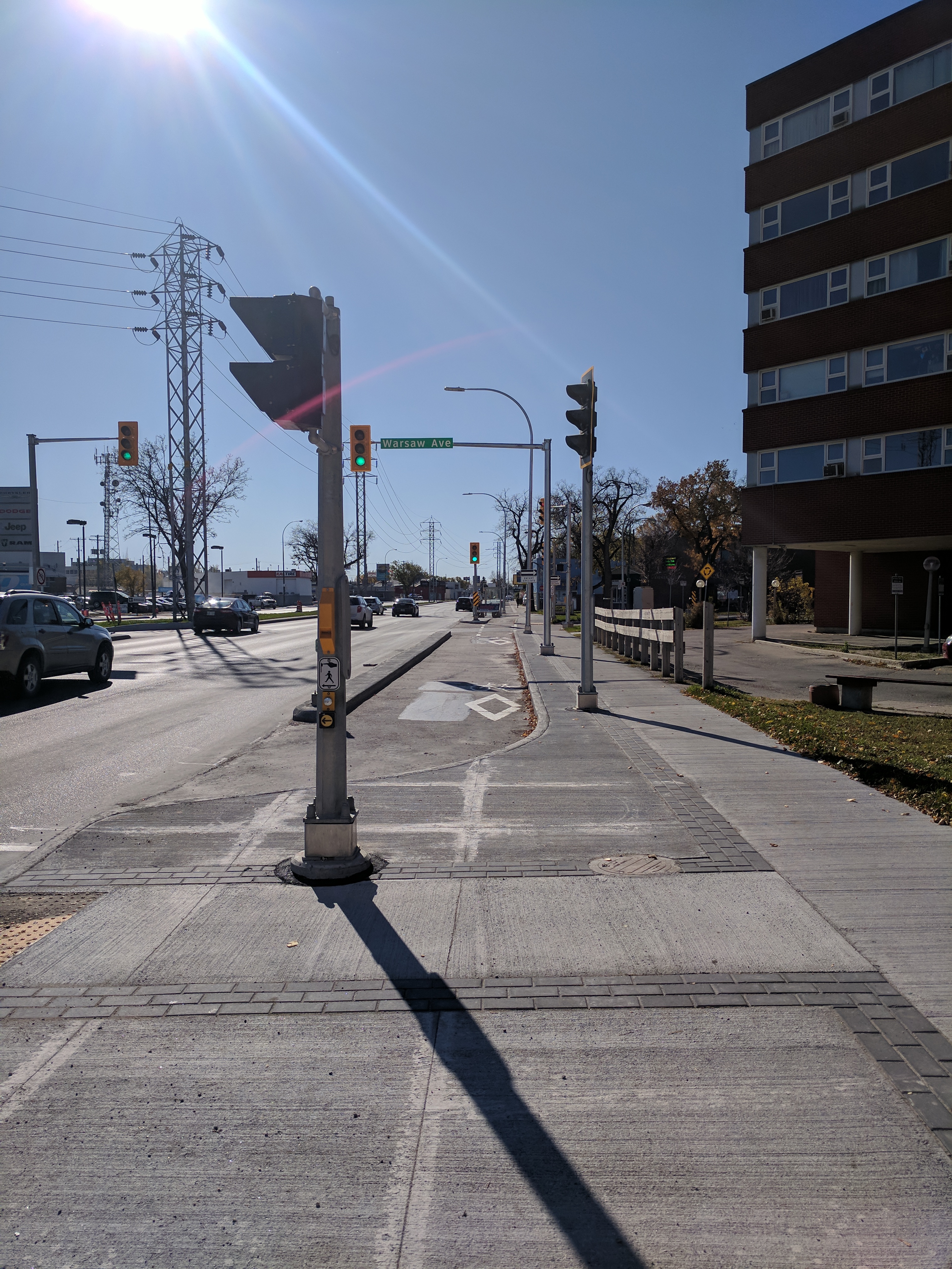
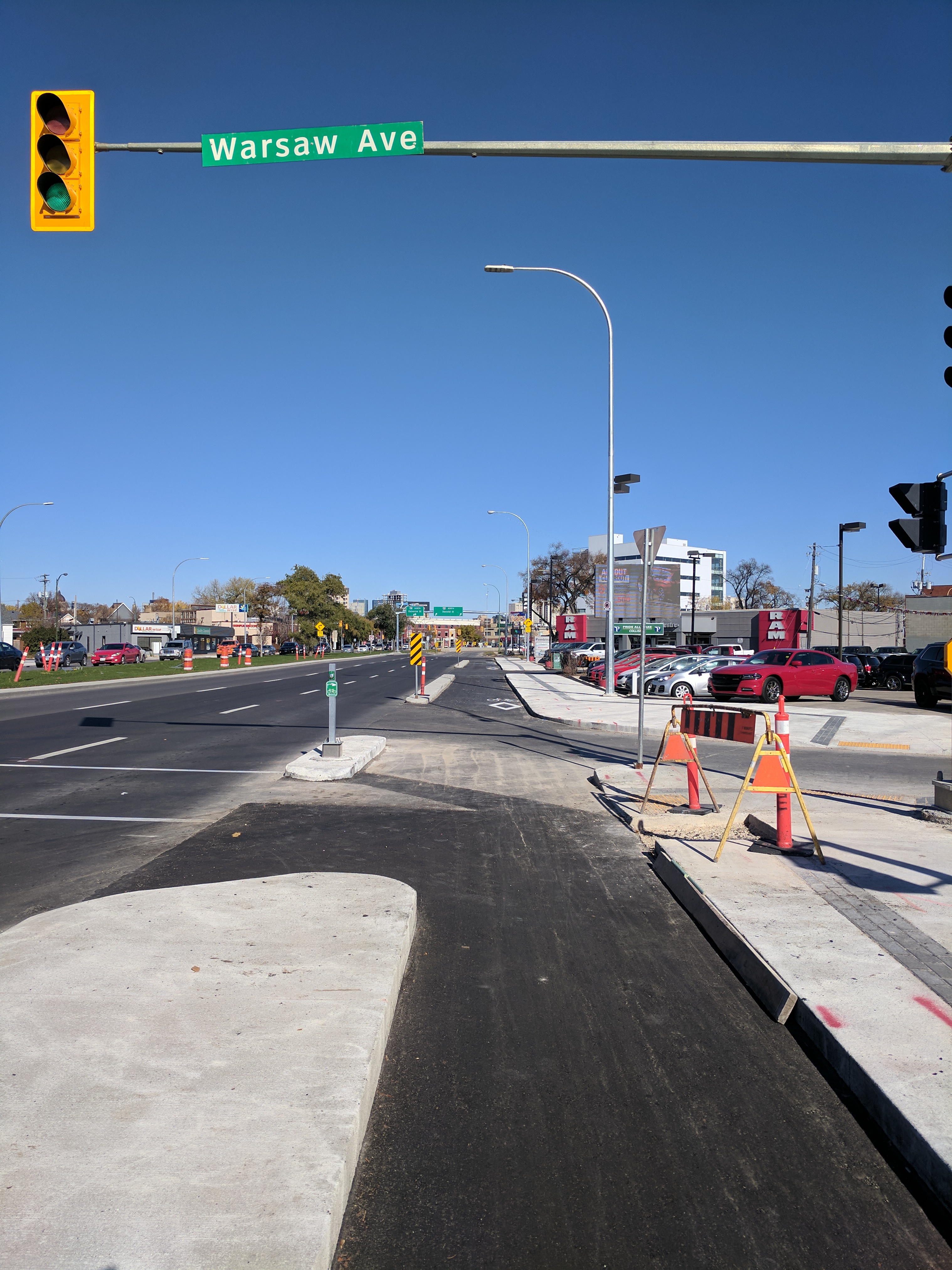
An all ages and abilities connection from Empress St to Alexander Avenue is possible using a mix of neighbourhood greenways along low volume residential streets in the Weston Neighbourhood, pathways along Saksatchewan Ave, Midland St, and the BNSF rail line, and a short two way protected bike lane segment along Notre Dame Ave between Dublin Ave and Spruce St. If implemented, the route would provide users with safe crossings of Notre Dame Ave, Weston St., McPhillips St, and Logan Ave at existing traffic signals or pedestrian corridors. Assuming future plans to extend the Northwest Hydro Corridor will include a safe crossing of Logan Ave, only the Elgin @ Keewatin crossing would require crossing improvements (push-button activation for the pedestrian corridor for people on bikes).
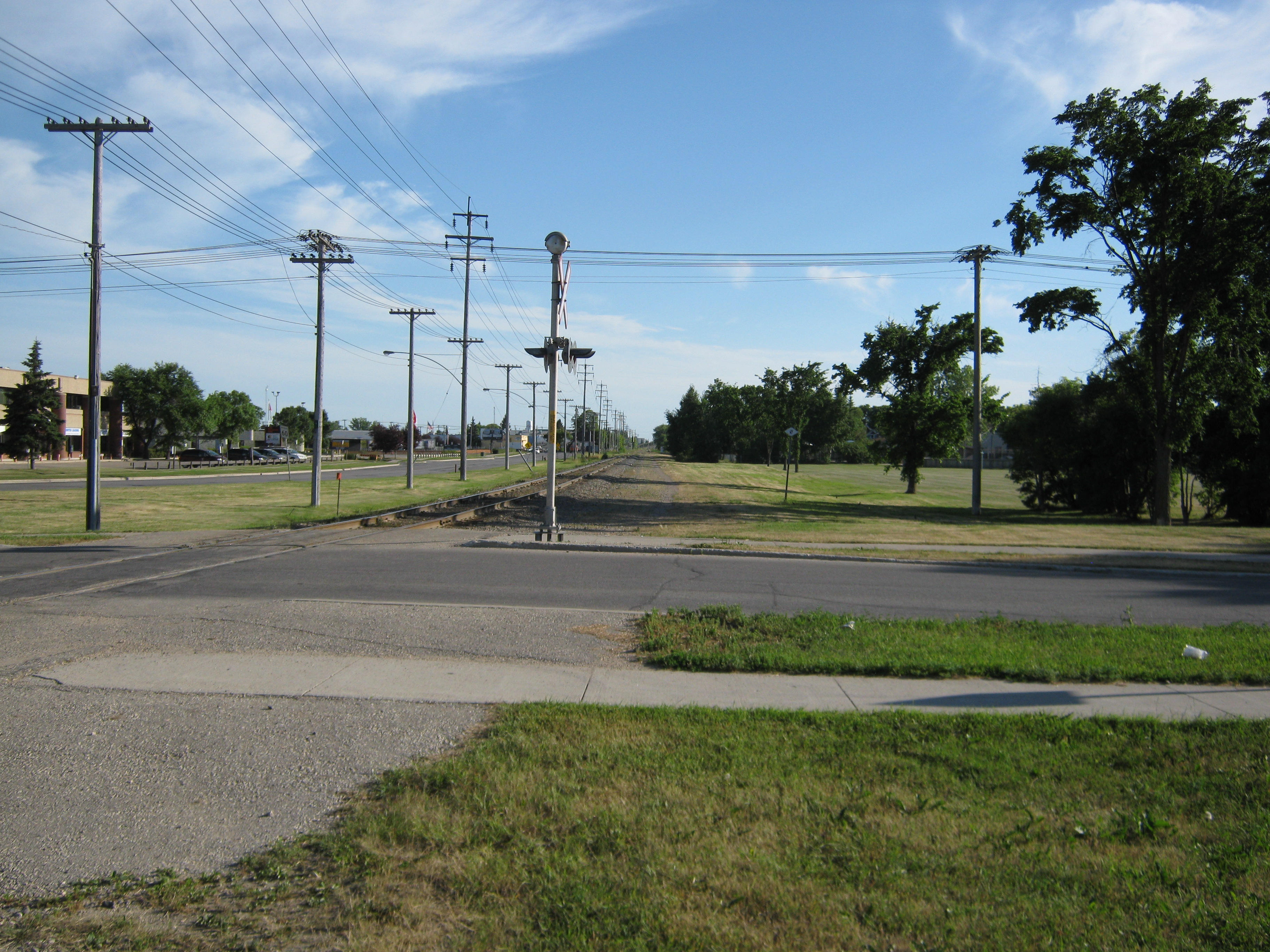
Looking south from Alexander Ave towards Notre Dame Ave, with Pascoe Park to the right.
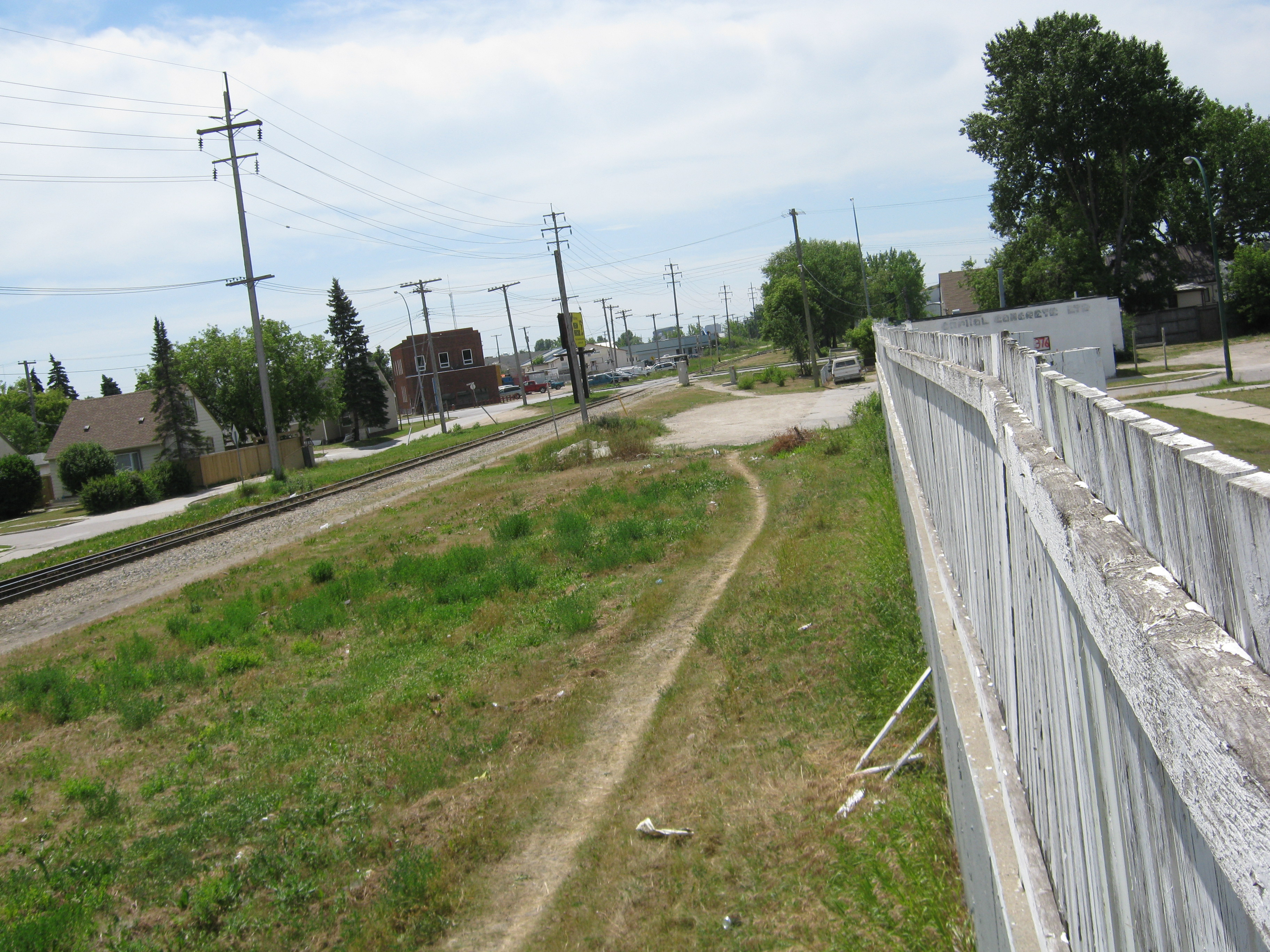
Looking north from Winnipeg Ave towards Alexander Ave and Pascoe Park. Note the well used pathway.
This two way bike lane on Pembina Highway could serve as a model for a two-way protected bike lane on Notre Dame Ave connecting Dublin Ave to Flint St and Spruce St.
This two way bike lane on Pembina Highway could serve as a model for a two-way protected bike lane on Notre Dame Ave connecting Dublin Ave to Flint St and Spruce St.
Replacement of the Omand’s Creek Bridge on Saskatchewan Ave in 2016 included provision for cycling facilities on Empress Street and a 2.5m wide sidewalk across Omand’s Creek that could accommodate a shared use pathway connecting Empress Street to a potential pathway along Saskatchewan Avenue leading to a Midland St pathway.
Include Connections to Alexander Ave in Planning for Empress St Pathway
We are asking that preliminary design of our proposed connections from the intersection of Empress St and Saskatchewan Ave to the intersection of Alexander Ave with Weston St, Lincoln and Pacific Avenues with Weston St, and improvements to the crossing of Keewatin St at Elgin Ave be added to the scope of the Preliminary Design Project for Rehabilitation of Empress Street between Saskatchewan Ave and St. Mathews Ave (set for 2023).
As there are no existing plans in the Pedestrian and Cycling Strategies for a crossing of the BNSF line to connect to planned Wellington Avenue Protected Bike Lanes (which serve as a spine in the bicycle network and connect through to Cumberland Avenue and the Downtown Protected Bike Lanes Network), we are also recommending that planning for the Empress St Pathway include a connection to the planned Clifton Neighbourhood Greenway via Notre Dame Ave and Spruce St.
More Information
- Northwest Hydro Corridor Greenway Backgrounder
- Keewatin Street Pathway Backgrounder
- Empress Street and Overpass Reconstruction and Rehabilitation Project (City of Winnipeg)
- 2018 Pedestrian and Cycling Program Action Plan (City of Winnipeg)
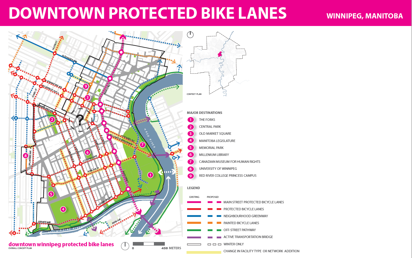
Complete the Downtown Protected Bike Lane Network
Downtown Separated Bicycle Lane Network
Despite having been identified as a short-term “quick win” that should be prioritized in the next one or two years.[1], construction of the city’s down town separated bike lane network is finally starting to take shape with the completion of the McDermot/Bannatyne Avenue protected bike lanes in 2018 (plus segments of the Princess, Notre Dame, Hargrave, and Carlton Protected Bike Lanes) and the expected completion of the Garry Street protected bike lanes in 2019.
Still, full build-out of the downtown separated bicycle lane network is not within the 3-year planning horizon of the 2018 Pedestrian and Cycling Program Action Plan, and even then the planned network will not provide the level of connectivity recommended in the Downtown by the Pedestrian and Cycling Strategies (400m grid width).[2]
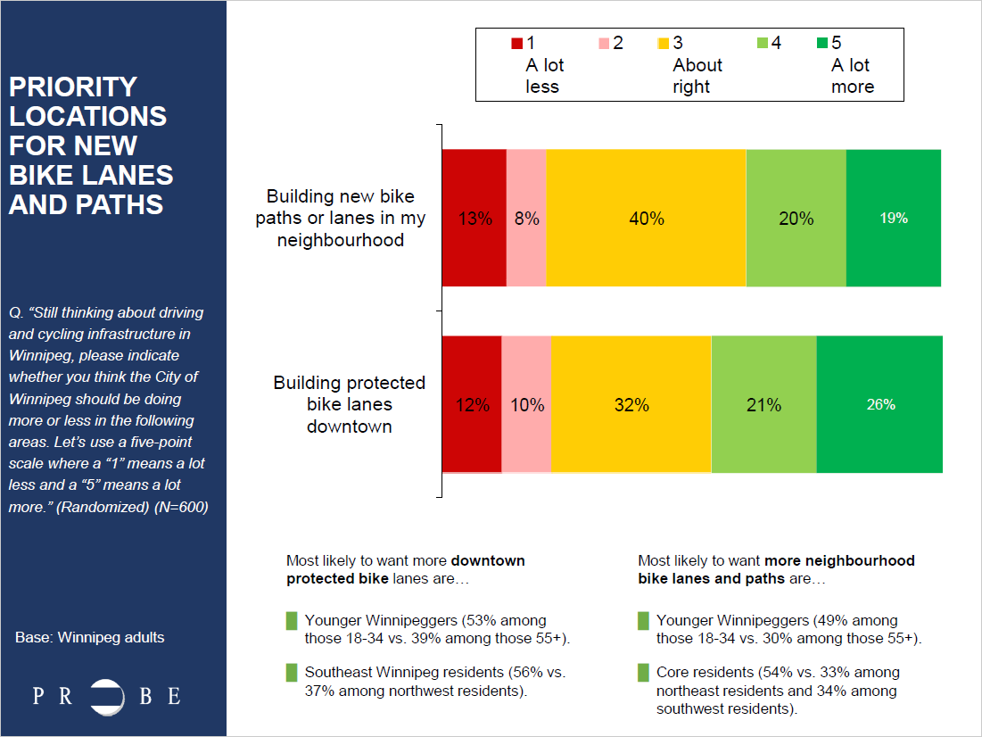
A June 2018 Probe Research poll found substantial support for installation of protected bike lanes in the downtown. When asked if they think the City of Winnipeg should be building more or less protected bike lanes in the downtown, almost half (47 per cent) of respondents said the city should be building more protected bike lanes downtown.
We urge the city to fast track development of the downtown separated bicycle lane network by committing to plan for all remaining segments (and proposed additions along St. Mary & York) in 2019, and by installing adjustable separated bike lanes in 2019/2020 to be followed with permanent installations as the roadways undergo planned renewals.
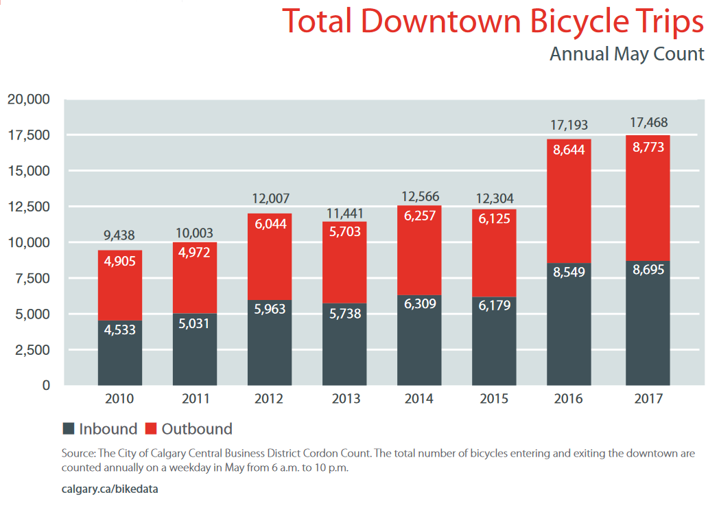
Case Study
In 2015, the City of Calgary fast tracked the planning and installation of a five street downtown protected bike lane network using cheaply installed adjustable barriers (similar to those being piloted in Winnipeg right now).
Results:
- Ridership has tripled along the network.
- Bicycle trips into and out of downtown increased by 40% between the 2015 and 2016.
- Perception of safety of people cycling increased from 68% to 91%.
- People are going one or two blocks out of their way to use the cycle tracks.
- The highest ridership occurs where cycle track routes are closer together.
Footnotes
[1] Page 312, Pedestrian and Cycling Strategies, City of Winnipeg, 2015
[2] Page 135, Pedestrian and Cycling Strategies, City of Winnipeg, 2015
East Corridor Rapid Transit and the Louise Bridge
Ward Boundaries: Legal Description Map (pdf)
Candidates: Dean Koshelanyk Vivian Santos Kate Sjoberg