
Chief Peguis Trail West Extension Recommendations

Introduction
Extension of the Chief Peguis Trail (CPT) from Main Street to Brookside Boulevard will be a major investment for the City of Winnipeg. It will be an important component of the City’s planned Inner Ring Road, as well as the northwestern segment of the cycling ring envisioned as part of the proposed bike network that has been based on the concept of a ‘hub and spoke’ model of high quality facilities that are attractive to people of all ages and abilities[1].
While the Chief Peguis Trail Extension provides many opportunities to improve/expand the city’s bike network, the extension of a high speed, limited access freeway has the potential to create many new barriers as well. This is further exasperated by the widening of many north/south roadways connecting into and crossing Chief Peguis Trail as these widened roadways also have the potential to become barriers to east/west travel on foot or bike.
These recommendations aim to take advantage of the opportunities to improve cycling connections within the study area by ensuring an adequate level of service for people biking along the Chief Peguis Trail corridor and by eliminating or at least minimizing any barriers on cycling routes connecting to and across the Chief Peguis Trail corridor.
Summary of Chief Peguis Trail West Extension Recommendations
- Extend Cycling facilities on Ferrier/McGregor south to Kingsbury to provide link to future cycling facilities on Leila and along the Winnipeg Beach rail line and a logical end point for the Ferrier/McGregor cycling facility at an existing low-stress roadway (Kingsbury).
- Change the at grade AT crossing at McPhillips to a grade separated crossing to match the level of service offered to motorized traffic on Chief Peguis Trail
- The widening of McPhillips to six lanes makes grade separation critical
- A through pass west of Main Street required by the RFP has been dropped, meaning no net increase in grade separated AT crossings is being recommended as part of the initial build.
- Plan for a future grade separation over the CPT along NW Hydro Corridor Greenway and ensure that its construction is included in any developer agreements related to Precinct D
- Reserve/Acquire necessary property for construction of a Pedestrian & Cycling bridge
- The NW Hydro Corridor Greenway is proposed as an off road spine in the city’s bike network that will provide connectivity between Precinct D, Seven Oaks Hospital, the McPhillips & Leila Regional Mixed Used Centre, and the Downtown.
- The importance of this crossing in the pedestrian and bicycle networks matches the importance of arterial streets which will be included in any developer agreements.
- Include cycling facilities along Pipeline Road as per the PCS.
- Preserve the Bergen Cut-off lands for future AT from Ritchie Street to Jefferson @ King Edward (or thereabouts)
- Add this right of way to the City of Winnipeg Bicycle Network as an off-street pathway
- Provides connection into Waterford Green trail system and School Site
- Provides connection to Castlebury Meadows Trail system
- Provides future connections for Precinct B
- Provides connections for Amber Trails neighbourhood
- Connects the western terminus of Amber Trails pathway to future Leila protected bike lanes/path
- Connects Bitterfield to CPT pathways via a linear park
- Ensure that future bicycle network facilities are displayed on all public engagement materials, especially those aimed at soliciting public feedback.
- Ensure that adopted precinct plans are displayed as part of future public engagement processes involving transportation or land development.
- Add this right of way to the City of Winnipeg Bicycle Network as an off-street pathway
What We Like
Main Street
We are happy to see the grade separated crossing of Main Street on the south side of Chief Peguis that will match up with the addition of a multi-use path on the south side of the Kildonan Settler’s Bridge. While our preference would have been to see some kind of grade separation for people on foot and bike across Chief Peguis connecting to the Frog Plain Trail and the Riverbend Neighbourhood, we recognize that the ramps needed to provide the elevation for such a crossing would likely have made the crossing distance too great in comparison to the at grade crossing, making it unpalatable for the majority of users who would likely opt for the at-grade crossing.
Templeton-Sinclair Grade Separation

Proposed site of Templeton-Sinclair Pedestrian and Bicycle Bridge
The location of the pedestrian/bicycle bridge north of the Templeton-Sinclair neighbourhood is well situated to provide connectivity into Precincts F (Aurora) and G from potential bikeways such as Sinclair, Beecher, and Diplomat.
Amber Trails Grade Separation

Proposed site of Amber Trails Pedestrian and Bicycle Bridge
The location of the Amber Trails pedestrian/bicycle bridge is well situated for use as a link between the Amber Trails neighbourhood and the Sikh Society of Manitoba Building and future Precinct B destinations, connecting directly into Strasbourg/Mandalay and the internal Amber Trails pathway network.
What Needs to be Improved
Ferrier Pathway – Extend Cycling Facilities South to Kingsbury
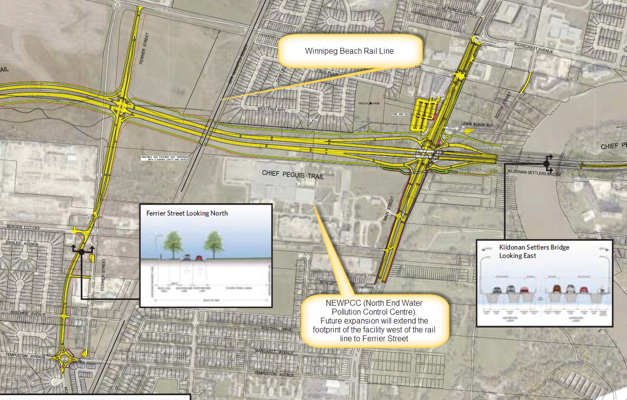
While the preferred north/south bikeway between Main Street and McPhillps would be the Winnipeg Beach Rail Line right of way, plans for expansion of the NEWPCC (North End Water Pollution Control Centre) across the rail right of way will block off this corridor between the Bergen Cut-off just north of Vince Leah Park and the Chief Peguis Trail. As such, a detour of this bikeway to Ferrier is required and a multiuse pathway along Ferrier has been included in plans for the CPT Extension project.
Ending the Ferrier Street cycling facility at Templeton would dump people on bikes onto a roadway where traffic volumes are incompatible with a mixed traffic facility, yet that is what is currently being proposed.
We strongly disagree with the decision to end the cycling facility on Ferrier at Templeton Avenue and recommend that it be extended across Leila and Partridge Avenues to Kingsbury Avenue so that it is ended at a logical location where it will connect with a low-stress residential street proposed as a future neighbourhood greenway in the City’s Pedestrian and Cycling Strategies. The RFP for this project clearly states that cycling facilities are to start and end at logical and safe locations such that new gaps are not created. Ending the Ferrier cycling facility at Templeton Avenue and directing people on bikes toward an uncontrolled offset crossing of Leila and Partridge at Powers leaves an unquestionable barrier to safe travel.
Traffic Volumes on Templeton are Not Suitable for a Neigbourhood Greenway
While the proposed CPT plan (and the City’s Pedestrian and Cycling Strategies) shows Templeton as a neighbourhood greenway (also known as a bike boulevard), traffic on Templeton is far too high to meet traffic volume guidelines for a neighbourhood greenway, which state a preferred traffic volume of 1,500 vehicles per day, with a maximum traffic volume of 3,000 acceptable only over a short distance[2]. In the absence of traffic calming to reduce traffic volumes on Templeton and Salter (unlikely given Templeton’s role as a collector street) along with traffic signals to facilitate a safe crossing of Leila and Partridge at Powers (it’s not clear how the connection from Salter to Powers is supposed to be made as Salter does not in fact connect to Powers) it must be assumed that no connection to the bicycle network will be provided.

Best Practice for the development of Neighbourhood Greenways (aka Bicycle Boulevards) from the National Association of City Transportation Officials (NACTO)
We think that a better way to provide the needed connection to the Ferrier bikeway, which will meet both the initial and ultimate needs of the City’s bicycle network, is to continue the Ferrier bikeway south along McGregor across Leila and Partridge Avenues to Kingsbury Avenue (identified as a potential neighbourhood greenway in the Pedestrian and Cycling Strategies), a low volume, east/west residential street with an existing crossing of the Winnipeg Beach Rail Line, completing the detour necessitated by the expansion of the NEWPCC.

Protected bike lanes on Ferrier/McGregor extending south to Kingsbury Avenue ( an existing low-stress roadway) would provide a logical end point for the Ferrier/McGregor cycling facility.
We see two potential options to provide a safe and comfortable connection:
- Our preferred solution would be to replace the multi-use pathway proposed on the west side of Ferrier with two one-way protected bike lanes between Chief Peguis Trail and Kingsbury Avenue.
- A less preferable option would be to keep the multiuse pathway treatment that has been proposed for the west side of Ferrier between Chief Peguis Trail and Templeton Avenue, but transition into two one-way protected bike lanes on McGregor Street south of the Templeton Avenue roundabout.
The first option is our preferred option as it provides a consistent cross section along McGregor, where a two-way protected bike lane is not suitable because of limited right of way width on McGregor and the high frequency of cross streets and back lanes that would need to be crossed south of Leila/Partridge.
The benefit of extending the Ferrier/McGregor bikeway south to Kingsbury instead of terminating at Leila Avenue or where McGregor Street intersects the Winnipeg Beach Rail Line right of way is that safe crossings of Leila and Partridge Avenues can be provided at existing signalized intersections (with the ability to provide protected intersections when protected bike lanes are installed along Leila Avenue). As a Functional Design for a bikeway on Leila Avenue has been proposed for 2019 in the City of Winnipeg’s 2018 budget, a clearly defined connection north from Leila to the Chief Peguis Trail and south to the Winnipeg Beach Rail Line would be a considerable advantage in the planning for that facility. Leila is identified as part of the protected bike lanes network in the Pedestrian and Cycling Strategies.
A comfortable bikeway on Ferrier/McGregor connecting south to Kingsbury Avenue would provide safe connections to the Winnipeg Beach rail right of way, where a rail to trail or rail with trail pathway could provide a high quality bicycle connection to Arlington Street and the new Arlington Street Bridge and its protected bike lanes over the CPR Yards into the Daniel McIntyre neighbourhood (we recommend that the protected bike lanes to be included in the new Arlington Bridge be extended north to Inkster Boulevard to complete this connection, although as part of a separate project). Similarly, any bikeway on Ferrier/McGregor would tie in to any future cycling facilities along McGregor Street that would be included in an extension of McGregor Street under/over/across the CPR Yards to Sherbrook Street (a possibility specifically referenced in the RFP[3]).
Preserve the Bergen Cut-off lands for Active Transportation
Active Transportation plans for Amber Trails and Precincts C (Waterford Green) & T (Castlebury Meadows) have been developed with the assumption that the Chief Peguis Trail would essentially follow the Old Bergen Cut-Off rail line and that an off-road multi-use pathway would be included along the southern boundary of the Chief Peguis Trail along this right of way[4]. With the decision to swing Chief Peguis Trail further north, off-road pathway networks in these neighbourhoods that were planned to connect to pathways along the Chief Peguis Trail will be left without those assumed connections, nullifying the commitment in those plans to an active transportation network that provides residents with safe and convenient spaces for pedestrians, bicyclists, public transit ridership and motorists to promote physical activity, health and active transportation.

Waterford Green’s pathway network was designed with the assumption that there would be a pathway along the Berger Cut-Off lands along it’s northern border

Castlebury Meadow’s pathway network was designed under the assumption that there would be a pathway along the Bergen Cut-Off lands along it’s northern border
For this reason, we recommend that every effort be made to preserve the Old Bergen-cut off lands for future use in AT pathways as a part of this planning process.
Suggested Improvements to the Public Engagement Process
Show the Proposed Bike Network on Public Engagement Materials
We feel that not showing the proposed bike network on printed maps used at the open houses to display plans and solicit feedback removed needed context from the public engagement process and diminished the role of walking and cycling in the public engagement process. People need to see how plans being presented for the Chief Peguis Trail fit into future bike network plans, but without the visual reminder provided by this important information, people are far less likely to not the need for connections, and the opportunity to solicit vital community input is lost.
Show Precinct Plans on Public Engagement Materials
As with the decision to leave planned improvements to the bike network off of the table maps printed at the open houses, we feel that the decision not to display adopted (or in the case of Precinct G draft) Precinct Plans removed an important piece of contextual information from the public engagement process. While planned roads were shown on display boards, walking and cycling facilities are not.
Precincts C, E, F, G and T all include plans for walking and cycling, parks, and high density or commercial centres that will need to be connected via the walking and cycling networks, but unless these plans are displayed, the need for these connections to be included in planning are unlikely to be considered. In the case of Precincts C and T, which as we have pointed out above depend heavily on the assumption that their walking and cycling networks will link in to pathways along the Chief Peguis Trail, the absence of these plans in the display materials made it very difficult to recognize that this shift in the planned route of Chief Peguis would affect the walkability and bikeability of these neighbourhoods.
What’s Missing
Grade Separation at McPhillips Interchange
Change the at grade AT crossing at McPhillips to a grade separated crossing to match the level of service offered to motorized traffic on Chief Peguis Trail. The widening of McPhillips to six lanes makes grade separation critical. A through pass west of Main Street required by the RFP has been dropped, meaning that a new grade separated crossing at McPhillips will not result in a net increase in grade separated AT crossings being recommended as part of the initial build.
If space for such a crossing is tight, we recommend changing from the planned diamond interchange to a more space efficient single point urban interchange as with the Main Street interchange.

A Pedestrian and Bicycle bridge needs to be included in the initial build across McPhillips Street, and one across the Chief Peguis Trail on the Northwest Hydro Corridor must be planned for when Precinct D is developed.
Plan for a Grade Separation of the CPT along the Northwest Hydro Corridor
The lack of planning for a future grade separated crossing of the Chief Peguis Trail along the Northwest Hydro Corridor is a serious omission and contradicts key recommendations of the Complete Communities Policy Document[5] and Pedestrian and Cycling Strategies[6]. While we are not asking for this facility to be built as a part of the initial build, as with plans to set aside or acquire lands for the eventual upgrade of at-grade intersections at Ferrier and Pipeline road to full interchanges at some point in the future, property acquisition is needed now to ensure the future feasibility of a pedestrian and bike bridge connecting Precinct D when that neighbourhood is developed.

The Northwest Hydro Corridor is identified as a high quality network spine in the Pedestrian and Cycling Strategies
As shown in the table below, distances from the nearest crossing in the vicinity of the hydro corridor are well beyond the recommended spacing of 800m found in the Pedestrian and Cycling Strategies.

Distance between proposed and potential AT crossings (estimated in metres) along the Chief Peguis Trail West Extension
Cycling facilities are absent on McPhillips, and unlikely to be provided at any time in the future. As such, the cycling facility planned along the Northwest Hydro Corridor (approximately 500 meters west of McPhillips) has been planned as a high quality bike network spine route connecting area residents to Seven Oaks Hospital, the McPhillips & Leila Regional Mixed Use Centre and eventually to the Downtown.
Surely the same rationale that has been used to recommend planning and property acquisition for a grade separated pedestrian and bicycle crossing of Brookside Boulevard along the Chief Peguis Trail as part of this project applies equally to this crossing, which in fact should be seen as having a far higher priority than the Brookside Boulevard crossing.
The importance of this crossing in the pedestrian and bicycle networks matches the importance of arterial streets for motorized traffic entering and exiting Precinct D. Arterial Roads are routinely included in developer agreements as a shared cost construction, and we feel that as the same logic applies to construction of a pedestrian and bicycle along the Northwest Hydro Corridor Greenway. As such, we are recommending that construction of this pedestrian and cycling bridge be included in any developer agreements for the future Precinct D.
Cycling Facilities on Pipeline Road
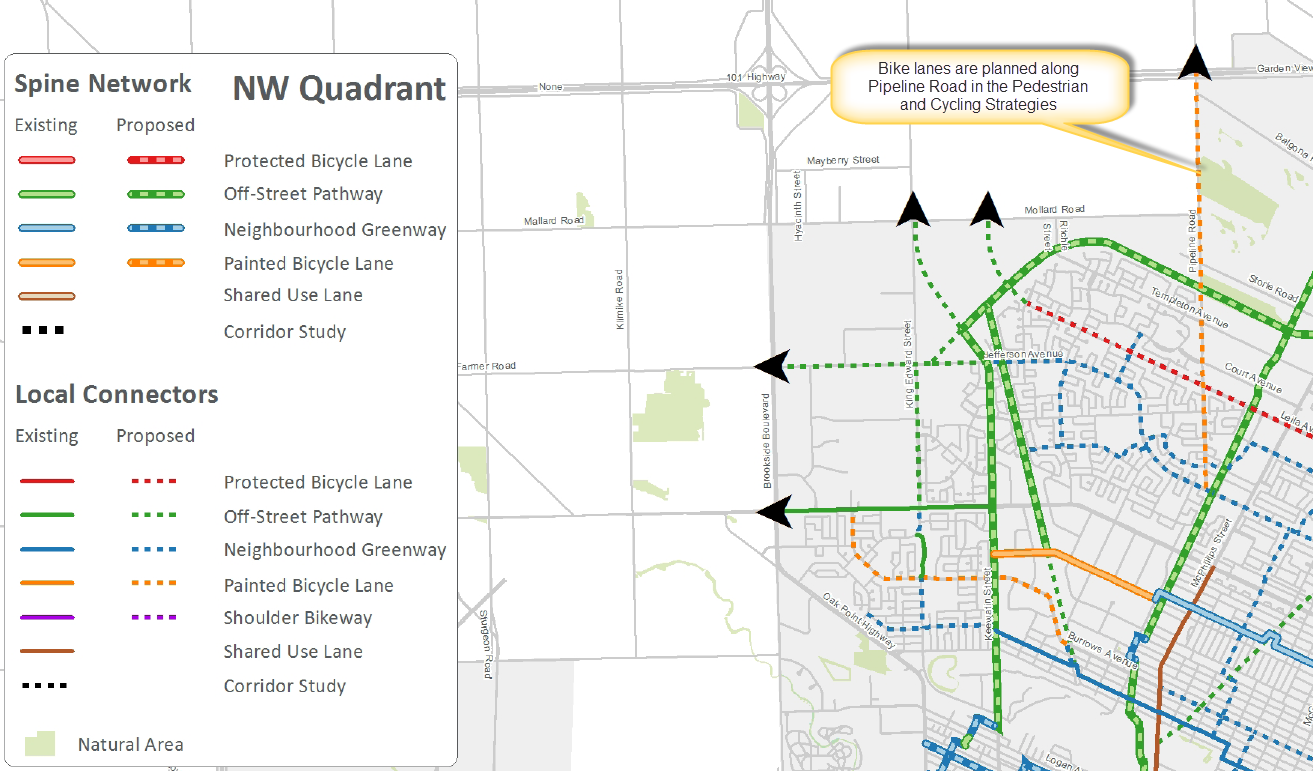
Bike lanes are proposed along Pipeline Road in the Pedestrian and Cycling Strategies.

Cycling facilities are notably absent along most of Pipeline Road in the proposed plan for the Chief Peguis Trail West Extension.
As a part of the bike network in the cycling strategy, we feel that proper cycling facilities (ideally protected bike lanes) should be included in the planning of any improvements to Pipeline Road, and that these improvements need to be extended north and south to logical start and end points.
More Information
- City of Winnipeg Chief Peguis Trail West Extension Study Portal
- Bike Winnipeg Submission (pdf)
End Notes
[1] City of Winnipeg, Pedestrian and Cycling Strategies. 2015. Pg. 154-155, Winnipeg
[2] National Association of Transportation Officials. (2013). Urban Bikeway Design Guide. New York: Author
[3] Request for Proposal, section D3.6 Ferrier – McGregor Realignment (pg. 15-16)
[4] Lombard North Group, Waterford Green Precinct Plan. 2012
C 2.1 Precinct Wide Urban Design Policies (Pgs. 14-15)
- Public Realm that Places People First
- Having green spaces, within which are paths that connect people within the community to schools(s), green space amenities, bus stops, and commercial amenities;
C 6 Parks (Pgs 23-25)
In Waterford Green an emphasis is placed on creating a well-integrated system of parks that supports and becomes part of the AT network (see section 7.4) – enhancing the connectivity within the precinct and extending out to significant areas in adjacent communities. The park space flanking the retention pond in the center of the precinct has become an important spine linking the active park space in the north to the space in the south and extending beyond to adjacent neighbourhood and the future regional AT corridor along Chief Peguis.
C 6.1 Park Policies
- Linear parks, and those parks having the primary purpose of accommodating a continuous path, should be designed to minimize the number of street crossings.
C 7.5.2 Active Transportation (AT) Network Policies (Pg. 28)
- The AT Network shall connect with existing and planned AT facilities adjacent to the Precinct.
- The AT network shall be designed, where possible and practical, to make it more convenient and attractive to access local and community amenities by AT than by using private motor-vehicle.
- The AT network will provide access to parks, sports fields, the Neighbourhood Mixed Use Centre, a school (if constructed), transit facilities and residential areas to facilitate connectivity and access for human-powered and public transit.
[5] City of Winnipeg, Complete Communities Policy Direction Document. 2011. Winnipeg – Regional Mixed Use Centres – Direction 1 (pg. 46) “Create strong, multi-modal and transportation linkages from each Regional Mixed Use Centre to Downtown, other Centres, Corridors, Parks and major attractions.”
[6] City of Winnipeg, Pedestrian and Cycling Strategies. 2015. Pg. 154-155, Winnipeg
· Direction 1B – Expand & Enhance the Bicycle Network
- Action I – Develop a complete, connected, and dense bicycle network throughout the City.
- Action iii – Develop a spine network to develop high quality connections to the Downtown from each area of the City.
- Action iv – Develop local bicycle networks for each neighbourhood that connect to the spine network and to the Downtown.
- Action vi – Continue to expand the off-street pathway network
- Action vii – Support the extension of the City’s Bike Network to surrounding communities.
- Action x – Ensure that bicycle requirements be addressed in all new and renewal road projects that are part of the bicycle network or where the road provides connectivity or support to the bicycle network.
- Action xi – Pursue bicycle network improvements that establish connections to major destinations throughout the City, including regional, community, and neighbourhood mixed-used centres and corridors, schools, libraries, and parks.
- Action xiii – Design new neighbourhoods to include bicycle routes that are well integrated with the existing bicycle network.
- Action xiv – Where possible, utilize existing hydro and rail rights of way and surplus road rights-of-way as a means to provide comfortable, direct cycling routes.
· Direction 1C – Address Barriers
- Action ii – Develop new pedestrian and cycling grade separated crossings or rivers, rail, and major road corridors.
· Direction 5A – Land Development and Site Design
- Action viii – Ensure that the bicycle network and sidewalk network provide connections to all Mixed- Use Centres and Corridors.