

Starts: Riel House National Historic Site
Tour Length: 20-25 km
Winnipeg is made up of a diverse collection of communities, and their early histories often reflect very different cultural backgrounds. While the northern areas were largely settled by English and Scottish immigrants, the south end of our city’s roots are primarily Metis and French. As we travel south we’ll be following the Red and La Salle rivers, which both played a pivotal role in the development of our city.
St. Vital was first settled in an organized way in the mid 1820s. The first to settle here were Metis families who had previously lived south, near Pembina, North Dakota. Many of these people moved north following conflicts with the Sioux (Lakota) people, and the early success of the Red River Settlement.
In these early days most families had small farms and depended on the annual bison hunts for meat. By the 1850s the economic importance of the bison had waned, and St Vital developed a major market garden economy to supply Winnipeg and St Boniface with produce. We’ll start by visiting the home of one of the most influential families in Manitoba’s early history: The Riels. Louis Riel Sr. was a miller who stood up for Metis trade rights and helped defeat the HBC’s monopoly on trade in the 1830s. His son, Louis Riel Jr., continued the family tradition and is considered by many to be the founding father of Manitoba. Have a look at the sign boards and visit Riel House for a tour if it’s open.
Tour Stops
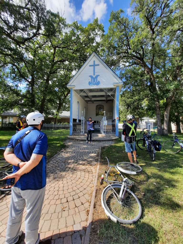
1 – Riel House National Historic Site

Built from 1880-81, this home was owned by Louis Riel’s mother, Julie Lagimodiere Riel. Louis only visited the home once in 1883, but he lay in state in the parlour following his execution by the Government of Canada in 1885. Louis’ wife and son lived here briefly following his execution. By 1908 Louis’ entire family had died, and he has no direct descendents today.
The property was once a superb example of a traditional Metis river lot: The Riel property stretched from the banks of the Seine River in the east, to the banks of the Red River in the west. These long, narrow river lots provided a mixed ecosystem and ensured each farmer was self-sustaining. Most families had access to the river for water, woodlands for heat and fertile prairie soil for farming. The house is located on the highest point of surrounding wetlands, to avoid floods.
It’s believed that the home was moved at least twice, and that the Riels originally lived on the banks of the Seine. Louis Riel Sr. operated a water mill there, which failed after several years due to unpredictable water levels on the tiny Seine. The Red River Frame style of construction allowed the house to be disassembled, moved, and rebuilt with the same materials.
2 – St. Norbert Intro/King’s Park
King’s Park was established around 1910 to encourage residential development around the University of Manitoba. The park was built around a Chinese/English colonial theme: Formal English gardens surround an unexpected Chinese pagoda. Until 2020 the park had matching red, arched bridges. These were moved to the Whiteshell and replaced with more accessible bridges.
Historically this area was a major hunting ground. As the bison migrated north along the prairie, they were easily trapped between the Red & La Salle (or Red & Seine) rivers. Beginning in 1822 the area was settled by retiring employees of the North-West Company–most of whom were Metis. These early families farmed and made their living through large, organized bison hunts and the sale of pemmican; or as tripmen who crewed york boats.
By the 1850s the HBC had largely stopped using york boats on the northern river route to Hudson’s Bay. St. Norbert became the gateway to the south — as convoys of red river carts now travelled overland along the Pembina Trail to the nearest railway in St Paul, Minnesota. This was the only land route for trade in or out of the Red River Settlement.
This made the area instrumental in the events leading up to the Riel Resistance and the birth of Manitoba in 1870. We were only a few days from American cities, while Ottawa was weeks away by canoe. The Canadian government feared Red River would be annexed by the US unless they made it here first.
Major shipping businesses and countless inns for travellers appeared. The area was increasingly settled by Quebecois families, who left a unique architectural legacy. The community’s roots as a hub for Catholicism and trade are still evident today, in many of the sites we will be visiting and the massive St Norbert Farmers’ Market.
3 – St. Norbert Market
Take a look at the “La Barriere” monument in the center of the plaza. The original monument here was a cross erected by Father Noel Richot which read “Le doigt de Dieu est ici” (The finger of God is here).
In 1869 the HBC sold all of their territory, including Red River, to the Canadian government for $1.5 million. Unfortunately they did not ask the people who lived here for their input. The government was convinced that the US planned to annex the Red River Settlement and cut their new nation in half. They sent a new Lieutenant Governor, William McDougall, with troops to take control of the territory and begin surveying for Canadian settlement. This angered the Metis, who saw their rights to this land being threatened by a government who had no authority over the region.
Louis Riel organized a group of 40 men who erected a barricade (La Barriere) across the Pembina Trail, blocking access for McDougall’s troops. This barricade was eventually defended by 100 men, who patrolled the area removing Canadian survey stakes from their farmland. The Canadian government was outraged and prepared for a conflict. In some ways we see similar tensions over Indigenous & Crown land claims continuing today, with similar actions on both sides.
4 – Place Saint-Norbert

McDougall House
Built for Marguerite McDougall & her sons in 1883, this house was originally located along the banks of the Seine River in Lorette, a Metis community. Her descendants lived in the house until 1965. There was tremendous upheaval during the events of 1869/70, and many families like the McDougalls fled St Boniface & St Vital fearing violence and persecution from the Canadian military. They settled in rural communities like St. Norbert and Lorette, which were largely untouched.
The home was moved to this location and restored in the mid 1980s. It’s style is typical of later 19th century architecture, and it was constructed in a very similar manner as Riel House. In this evolution of the Red River Frame style, logs are overlaid at the corners to create a dovetail-style joint, which supports the walls. The entire house was built by hand, with log walls and rough home-made siding. Milled lumber (like the boards we would buy today) was expensive and hard to obtain, even at this late date.
Pembina Highway House
First built around 1884, an addition was built around 1903. It was built by Elie Brisebois to house his family and their butcher shop. It quickly became part of St. Norbert’s commercial centre, and it served as the community’s post office from 1927 – 1973. The home was moved to this location in the mid 1980s with the McDougall House. The old and “new” sides can easily be distinguished, with a curious double set of doors. This kind of mixed residential and commercial development was normal, as most families lived in or above their businesses. The ornate gable windows and delicately curved roofline identify this house as Second Empire Style. The distinctive style was influenced by Napoleon the 2nd’s ornate building projects in Paris. It is a very unusual style in Winnipeg, and is generally only seen in communities with French connections, such as St Norbert and St Boniface.
Asile Richot / Richot Orphanage
Perhaps the most visible building in St Norbert, it towers over the nearby market. The first building on this site was a private home, built for Joseph Lemay. In 1903 his home was donated to the Souers de Misericorde and used as an orphanage. The current building was constructed by the sisters in 1911, and was used as an orphanage until 1948. It’s currently a rehabilitation center owned by the Behavioural Health Foundation.
Its design is typical of institutional structures built in the early 20th century, but it incorporates very unique and extensive balconies. The smaller annex to the side is more appropriate for the community, reflecting the Second Empire Style with its sweeping roof and gable windows.
5 – St. Norbert Parish Church
The imposing parish church here is relatively modern, but this intersection has always been a major gathering point. The community’s first log church was built in 1857, replaced with brick in 1883, and destroyed by a fire in 1929. The current church was re-built in 1937.
6 – Chapelle de Notre-Dame-du-Bon-Secours
Across the street sits La Chapelle. This original 1875 structure is a rare surviving example of an open-air church. Once very common in Red River, these buildings created a simple, communal gathering space.
Father Noel Richot had the chapel built to give thanks for the Virgin’s protection of the community during the 1869-70 Riel Resistance. Ritchot served as the main negotiator between Riel and Canada, and he deserves much of the credit for arranging Manitoba’s entry to Confederation on the condition that they guaranteed French language and Metis land rights.
Meanwhile the Canadian government dispatched troops under the Wolseley Expedition, and refused to respect most of these terms once their military had arrived. Many of these soldiers were Orangemen (a militant anti-Catholic, anti-French group), and they set about a campaign of state-sponsored terrorism. They harassed, assaulted, and even murdered members of the Metis community, while the government supported a flood of English settlers from Ontario.
Father Richot responded with an active campaign to recruit French Canadian settlers to this area, in order to maintain the Catholic church’s power and the community’s character. In 1870, over 80% of Manitoba’s population identified as Metis. By 1885, this number had dropped to 5%. The chapel contains 12 stained glass windows, and all of the features of a cathedral in miniature form. The statue of Mary is original, and was incredibly made of papier mache in 1875. Mary holds a sceptre (a symbol of power) facing down. This is said to represent the Metis victory over the Canadian government. The ceiling murals are reproductions painted by Robert Freynet in 1994. The 1885 originals, made by Constantin Tauffenbach are now stored in the parish church across the street.
7 – St. Norbert Provincial Heritage Park

This Provincial Park was established in the late 1970s, and four houses were moved here in the 1980s. Two of these have been restored while two have been left as deteriorating ruins.
A self guided trail explores the area’s history from Indigenous hunting grounds, to Metis trade hub, to French Canadian agricultural settlement.
Outdoor Refrigerator
Buildings like this would have been used for refrigeration on a working dairy farm, or market garden. It works like a giant ice box: Huge blocks of ice are loaded in, and a clever design allows air circulation. Ice blocks were cut from the river in the winter, packed in sawdust, and stored until summer in insulated warehouses.
Bohemier House
Built in 1888 by Benjamin Bohemier, a prominent Quebecois immigrant. The Bohemier family had at least twelve children, and their descendents lived in the home for 84 years.
The house has been restored to show the family’s lifestyle in the 1906-1912 period, and may be open for visitors during the summer months.
Originally located just north of the Perimeter on Pembina Highway, it was moved here in 1979 and restored in 1985. Notice the distinctive, complicated roof shape and dormer windows. It resembles Second Empire style in some ways, but is a very unique and progressive piece of architecture for a prairie farm house. It’s obvious that the Bohemier’s had cosmopolitan taste.
Turenne House
Built in 1871 by Joseph Turenne, also an immigrant from Quebec. He was recruited by the church to serve as a public official, as there were few French schools and formally educated people in the Settlement. Their home was originally located along the Red River near the parish church we visited. That site also held a ferry across the river, making it a major hub for the community. In 1882 the Turennes moved to St Boniface, and the house was used as a rental property for 89 years (until 1971). The Bohemiers actually rented this home when they first arrived here, as did a number of Grey Nuns.
Delorme House
This ruined home was built around 1855-58 by Pierre Delorme. He served as a member of Louis Riel’s Provisional Government and was the leader of the St Norbert Metis community. He later worked as a justice of the peace, Member of the Legislative Assembly and Member of Parliament.
Delorme was an important figure in Manitoba’s early history, and the neglected state of his home is surprising. It does offer an interesting ‘inside look’ at the Red River Frame (or tongue and groove) style of architecture. The house was originally located in St. Adolphe and was used as a waystation for traders on the Pembina Trail. It was moved here in 1982.
Henderson House
Built in 1854 or 56 for the family of Samuel Henderson. The Hendersons were one of the most prominent families in north-east Winnipeg, working as politicians and government officials. Their home is another example of local Red River Frame log construction.
It was originally located on Henderson Highway just south of the Perimeter. In 1979 the property owner wanted it removed so that he could build a more modern home. It was offered to the City to create a museum for North/East Kildonan, but this idea was rejected and it was moved here. A group called the North-East Winnipeg Historical Society still hopes to return the building to its community and restore it for use as a museum.
8 – Notre-Dame des Prairies

These are the ruins Ruins of Notre-Dame des Prairies, a Trappist monastery. The first group of monks travelled here in 1892 and built this site in 1905. Their monastery featured simple romanesque architecture to reflect the order’s values, and was built to plans sent from their home abbey in France.
It was occupied by the monks until 1978, when they moved to Holland, Manitoba, to escape the encroaching city. At the time this was written, the order of monks was trying to sell their current monastery site. The order is dying out, with only a few very elderly members left.
In 1983 the empty chapel and monastery were destroyed by an arsonist. Fortunately the nearby Guest House was not damaged and this site became a Provincial Park in 2002.
30 – 45 monks lived here at a time, and the monastery was meant to be completely self-sufficient. The monks operated a sawmill, forge, apiary, cheese making house, bakery and numerous greenhouses. This self-sufficiency allowed them to maintain isolated, austere and contemplative lives apart from the modern world.
9 – Guest House / St. Norbert Arts & Cultural Centre
The monastery’s Guest House was built in 1912 on the foundations of a previous 1892 building. It’s an imposing example of the French Second Empire style, with a sweeping mansard roof and countless dormer windows. It was designed and built by the monks to house visitors, and is the last remaining original part of the monastery.
Since 1991 the guest house has been home to the St Norbert Arts & Cultural Center. It is used for artists’ studios, concerts and community events. The site also maintains its spiritual purpose: The grounds contain meditation gardens, sweat lodges and ceremonial areas.
Explore the site and look for the golden ‘World Peace Pagoda’. This building is a Buddhist monument intended to promote world peace. The project was launched by a Japanese monk named Nichidatsu Fuji after the atomic bombings of Hiroshima and Nagaski. More than 80 of these buildings exist around the world, but this is the only one in Canada. This particular design was built by Manitoba’s Buddhist community under the guidance of the Venerable Sayadaw U Thile Wunta of Burma
Conclusion
While St. Norbert may now be a suburb of Winnipeg, it still holds a remarkably strong community identity. Its architectural and cultural history are clearly unique and well preserved.
We’ve travelled to one of the most remote communities on our tour, but its history stretches back as far as any other area of our city. It’s tempting to wonder why these early communities were established so far from each other.
This early urban sprawl was dictated by more than just geography or resources. An 1817 treaty signed between Lord Selkirk, Chief Peguis and four other Indigenous leaders limited where settlement was allowed. The settlers were restricted to an area around the Forks and directly adjacent to the rivers. They also agreed to pay an annual rent in exchange for use of the land. The rent was never paid, the settlement grew, and the treaty was quickly ignored. Peguis spent his later life writing letters to the Queen of England and asking for the treaty to be honoured. Winnipeg’s oldest centres are still spread out along the rivers, and the city has slowly filled the areas in between.
It’s worth remembering that today, Winnipeg is 204 years behind on its rent.
The Pedal into History project was supported by contributions from the Province of Manitoba through the Heritage Grants Program., the City of Winnipeg, and Seven Oaks House Museum. We are grateful for their support.