
To help Council Candidates and Voters better understand cycling policy and infrastructure project priorities, Bike Winnipeg has put together a number of policy and infrastructure recommendations that we hope can be moved forward in the next term of council.
Local Priorities for Walking and Biking
North Winnipeg Parkway Improvements
The North Winnipeg Parkway links Kildonan Park and the Chief Peguis Trail pathways to St; Juhn’s Park, beneath the Harry Lazarenko (Redwood) Bridge, through Michaëlle Jean Park to Rover and Annabella where it connects with the pathway along Waterfront Drive.
Numerous sections of the existing pathway are substandard, especially between Michaëlle Jean Park and St. John’s Park, and should be upgraded. A $400,000 study to look into options for its improvement is currently scheduled for 2019.
Access Between Harry Lazarenko Bridge & St. Johns Park
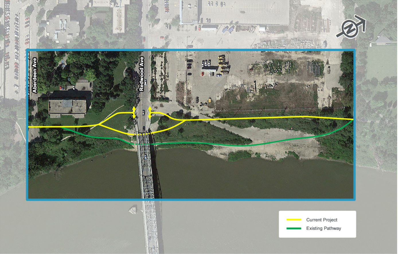
A raised pathway beneath the Harry Lazarenko (Redwood) Bridge is planned to fill a critical gap in the North Winnipeg Parkway, but it’s completion has been stalled by the absence of a needed property easement.
A particularly bad section of the pathway is the section of path that leads under the Harry Lazarenko (Redwood) Bridge north to St. John’s Park. This section of the pathway is prone to flooding, isolated, and in poor repair. Improvements to this section of trail have been scheduled since 2009, but have been held back by lack of a property easement north of the bridge.
As this is a critical link in Winnipeg’s cycling network, we feel that the city will have to look at expropriation if it cannot come to terms with the property owners for an easement that would allow for the needed improvements.
More Information
North Winnipeg Parkway – Redwood to St. John’s Park (City of Winnipeg)
Arlington Bridge and Protected Bike Lanes
The Arlington Bridge is nearing the end of its life and must be replaced. A plan for replacement of the bridge and installation of protected bike lanes between McDermot Avenue and Selkirk Avenue has been developed over the last 4 years through an extensive public engagement process. The expected completion date for replacement of the bridge and associated work on Arlington would be 2023 or 2024, but only if funding for detailed design and construction is approved. The latest estimate for the cost of the bridge is $330 million, however no construction funding is currently approved.

Plans for a new Arlington Bridge will include protected bike lanes between McDermot Avenue and Selkirk Avenue. Although the bridge is at the end of its usable life, funding for bridges replacement has not been approved.

Plans for the replacement of the Arlington Bridge include protected bike lanes that will run from McDermot Avenue to Selkirk Avenue.
Extending Protected Bike Lanes to Portage and Inkster
To fully capitalize on the investment being put into the Arlington Bridge replacement and its accompanying protected bike lanes, those bike lanes need to be extended south to Portage Avenue (with further improvements south to Westminster or Wolseley) and north to Inkster Boulevard.

Cycling potential along Arlington Street

Arlington transects some of the city’s most disadvantaged neighourhoods
Arlington intersects all of the major east/west bikeways in the northwest quadrant of the city, running through sections of the city with the highest potential for cycling and some of the city’s least advantaged neighbourhoods. Arlington’s potential to encourage new bike trips and improve people’s well-being is likely unsurpassed in Winnipeg.
Arlington is scheduled for a major rehabilitation between Notre Dame and William in 2022 at a cost of $5 million. To make sure that this rehabilitation includes the protected bike lanes that Arlington calls out for, a preliminary study should be initiated by 2020 at the latest to give enough time to allow for proper public engagement, detailed design, and purchase of any surface parking that may be required to provide protected bike lanes throughout Arlington’s length.
More Information
A Better Bridge for Arlington (City of Winnipeg)
Maple Street Through-Pass
The Maple Street Through-Pass is a potential link beneath the CPR Mainline that would provide an at grade connection between North Point Douglas and South Point Douglas for people on foot or bicycle. The through-pass would make use of an abandoned through-pass along the Maple St. right of way.
It’s listed in the 2018 Pedestrian and Cycling Program Action Plan as an unfunded project with an estimated cost of $6 million.
Leila Avenue Bicycle Facility Study
The Pedestrian and Cycling Strategies identify a need to install protected bike lanes on Leila Avenue as part of a key east/west connection across the north end of the city. The 2018 Pedestrian and Cycling Program Action Plan forecasts spending of $250,000 in 2019 for a Functional Bicycle Facility Study on Leila Avenue to engage the public and develop a functional design for the installation of protected bike lanes on Leila.
Leila is scheduled for major rehabilitation work between McGregor and McPhillips in 2020. Estimated cost for the rehabilitation project is $6.2 million, and should include installation of the planned protected bike lanes as part of the project.
Potential Inkster Boulevard Bikeway
While Inkster Boulevard is currently not part of the city’s planned cycling network, we think that it should be. Its wide median (nearly 12m) provides ample room for a bike path. A bike path in the median on Inkster would provide a comfortable, direct connection between the Northwest Hydro Greenway (just west of McPhillips) to the North Winnipeg Parkway (along the western bank of the Red River).
With rehabilitation work between Arlington and McKenzie scheduled for 2022, it makes sense to plan for a preliminary study in 2020 or 2021 to ensure that this work can be included within that project, and complimented with a a bikeway corridor project that could extend the pathway from Main Street to Fife.
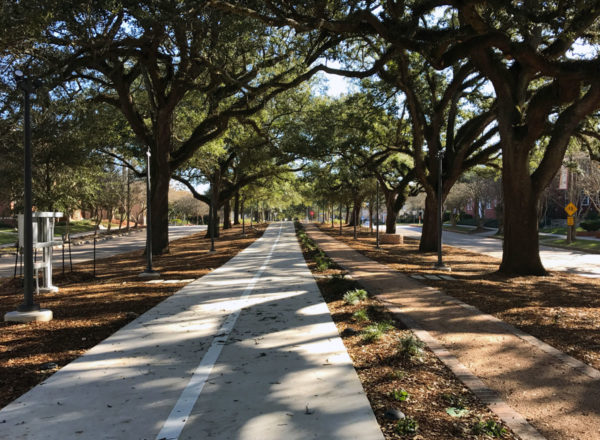
Bike path and sidewalk in the median of North Blvd in Baton Rouge.
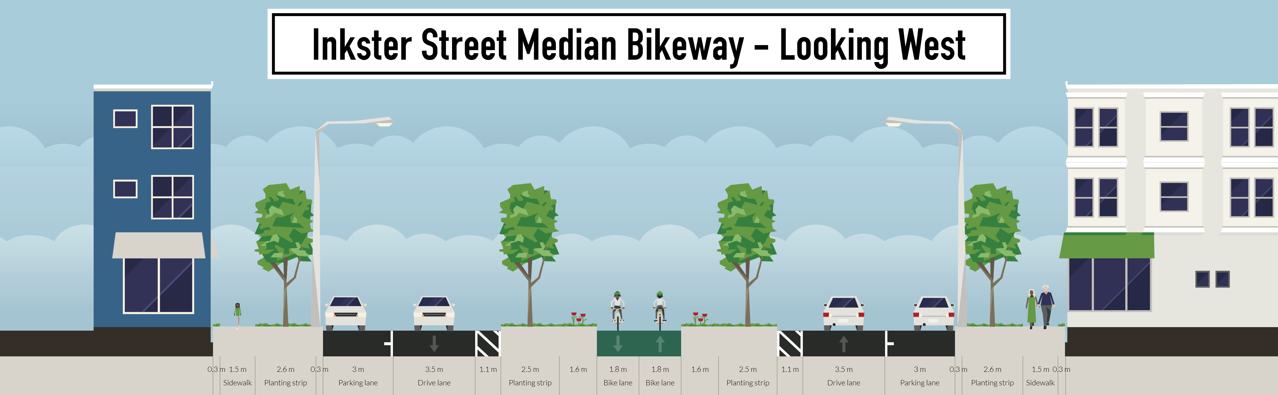
A potential cross-section for a median bike path along Inkster Blvd.
Seven Oaks-Jefferson-Garden City East/West Neighbourhood Greenways
Seven Oaks/Kildonan Dr Walk/Bike Bridge
The City of Winnipeg’s Pedestrian & Cycling Strategies calls for a dense, connected bicycle network to be developed over the next 20 years that will provide direct routes to key destinations. Included in the strategies is a recommendation to develop a new pedestrian & bicycle crossing of the Red River connecting connecting Scotia Street (near Rupertsland) to Kildonan Drive (Bronx Pl.).
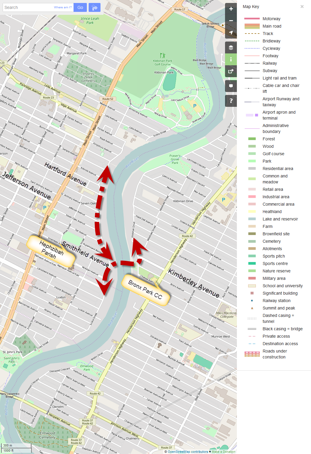
Suggested location of Scotia St – Kildonan Dr AT Bridge (map courtesy OpenStreetMaps.org)
New Neighbourhood Connections
A new Scotia St – Kildonan Dr AT Bridge would provide an important walking and cycling connection across the Red River at a point where access along the east bank of the Red River is restricted to Henderson Highway and beyond. This would create shortened travel distances for people walking or cycling between the Munroe West and Scotia Heights communities, as the nearest bridges are current the Kildonan Settlers Bridge (Chief Peguis Trail) and the Harry Lazarenko Bridge (Redwood). As the Harry Lazeranko Bridge is not a particularly bicycle friendly bridge, in reality, most people riding their bikes are currently choosing between the Kildonan Settlers Bridge and the Disraeli AT Bridge.
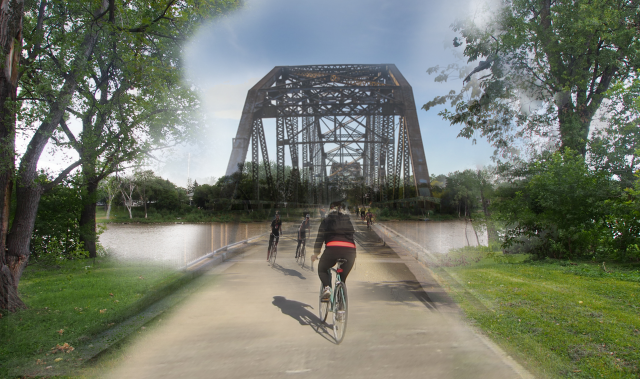
Mock up of Scotia St – Kildonan Dr Pedestrian & Bicycle Bridge
Based on estimates developed for the U of M St. Vital Pedestrian & Bicycle Bridge back in October of 2013, we estimate that the cost of construction for a Pedestrian & Bicycle Bridge linking Scotia St to Kildonan Dr would be about $15 million.
Further Reading
City of Winnipeg Pedestrian & Cycling Strategies
Ward Boundaries: Legal Description (pdf) Map (pdf)
Candidates: Dave Capar Ross Eadie Greg Littlejohn Michael Wiens