
To help Council Candidates and Voters better understand cycling policy and infrastructure project priorities, Bike Winnipeg has put together a number of policy and infrastructure recommendations that we hope can be moved forward in the next term of council.
Local Priorities for Walking and Biking
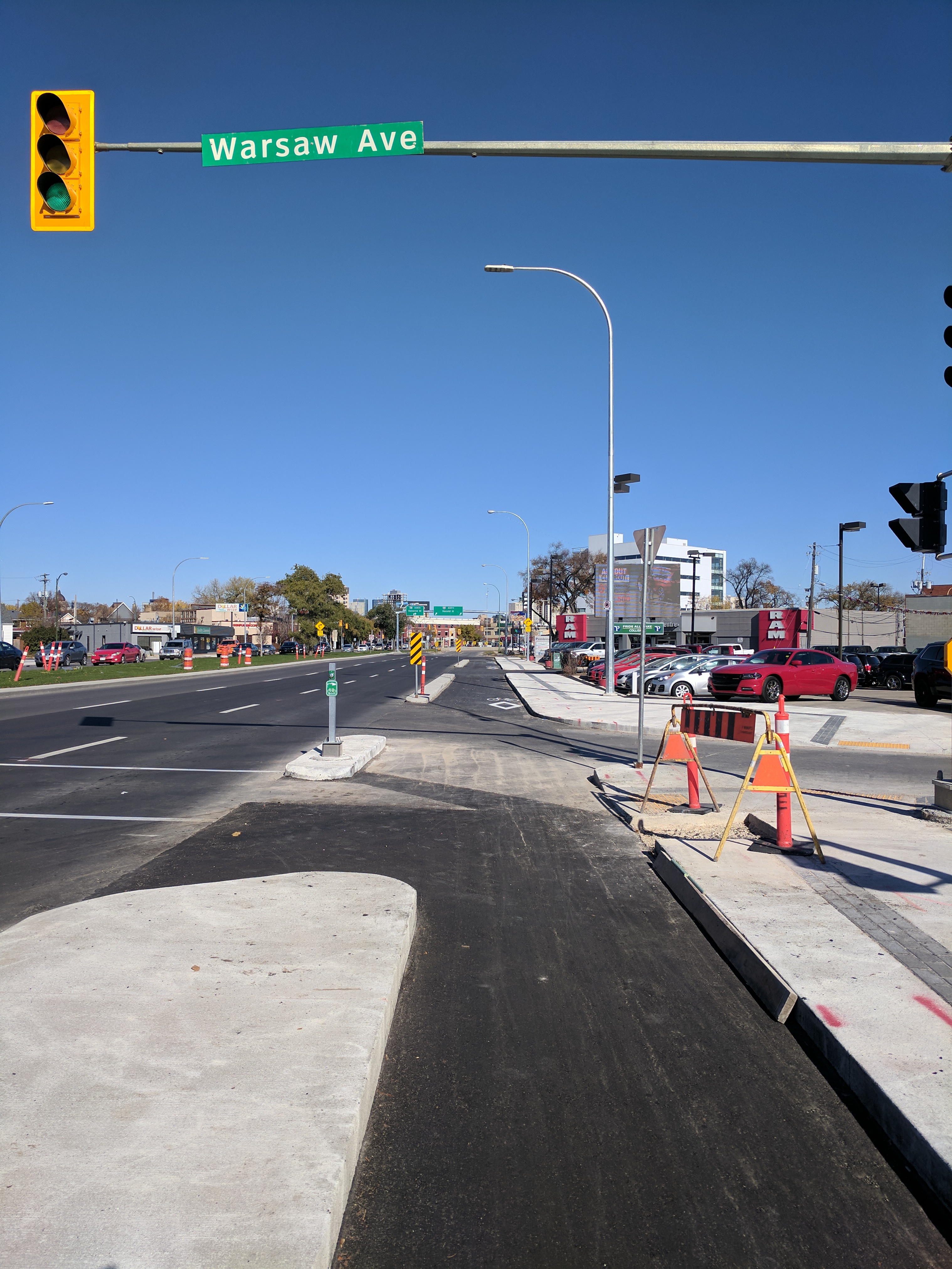
Arlington Bridge and Protected Bike Lanes

Plans for a new Arlington Bridge will include protected bike lanes between McDermot Avenue and Selkirk Avenue. Although the bridge is at the end of its usable life, funding for bridges replacement has not been approved.

Plans for the replacement of the Arlington Bridge include protected bike lanes that will run from McDermot Avenue to Selkirk Avenue.

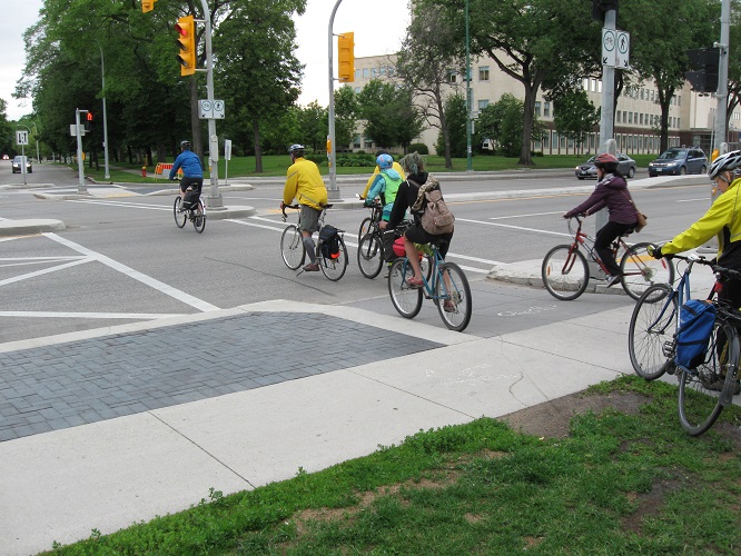
Cycling potential along Arlington Street

Arlington transects some of the city’s most disadvantaged neighourhoods
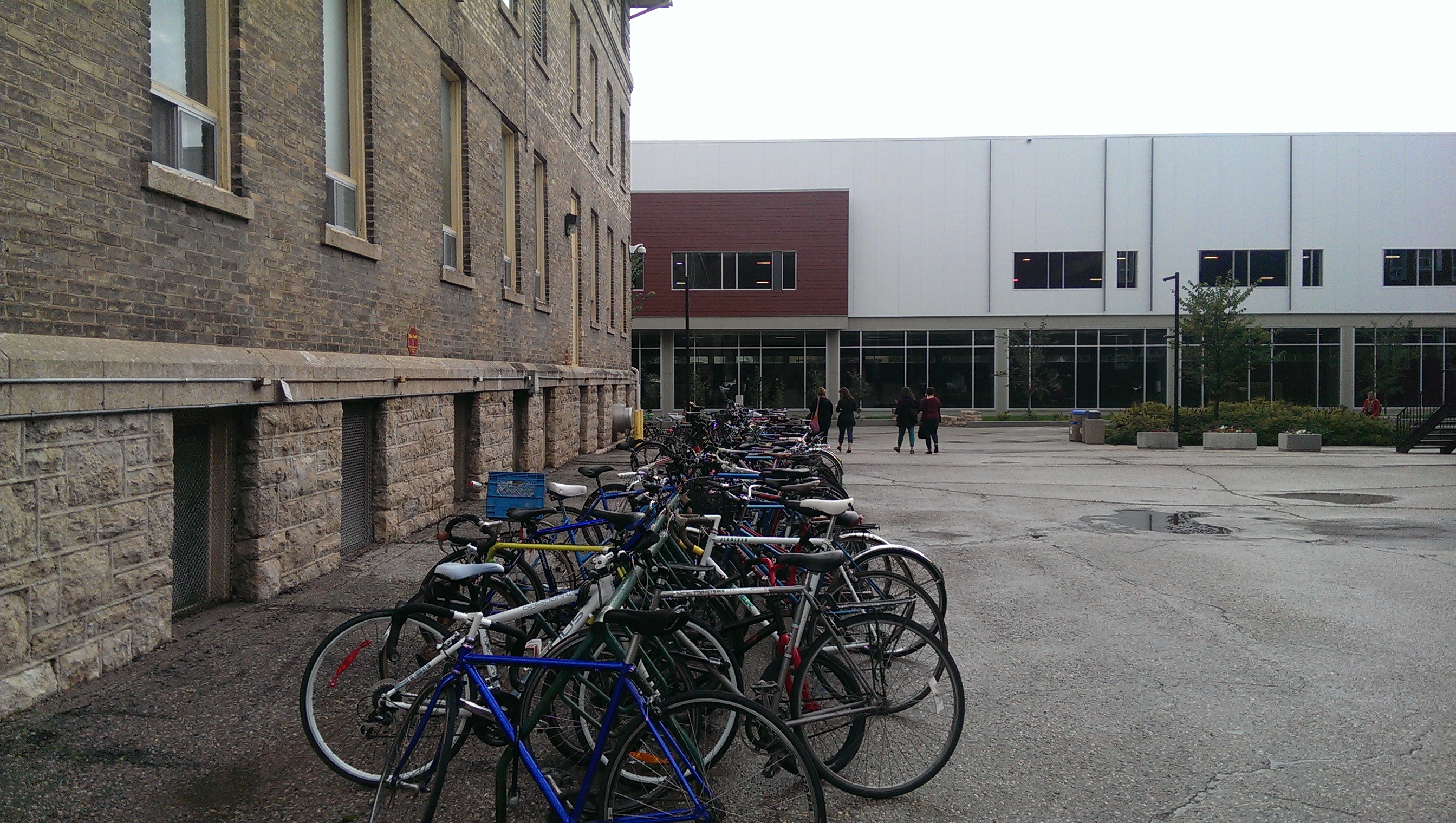
Improve Bicycle Connections to the U of W
With over 10,000 students, staff, and faculty, the University of Winnipeg’s Downtown Campus is one of the Downtown’s most important destinations. If we want to get more people biking more often, we will have to ensure that the U of W’s Downtown Campus is served by multiple low stress bikeways that are direct, convenient, and comfortable. With the high volume of trips coming into the U of W, it is also important that the bikeways we develop to provide access to the University are built to manage a high number of cyclists.
Improvements to the Maryland/Sherbrook bikeways and the recent upgrade of painted bike lane to protected bike lanes on McDermot and Bannatyne Avenues, combined with planned upgrades from painted to protected bike lanes on Hargrave St (Study & Functional Design in 2020), Ellen/Carlton St (Study & Functional Design in 2020), Garry St (construction in 2019), and Princess St (Functional Design 2018) will provide a vast improvement to bikeway connections to the U of W Campus, but the final few blocks between these bikeways and the U of W have little to no facilities for people on bikes. Certainly nothing that would qualify as an all ages and abilities bike route.
St. Mary Ave Protected Bike Lanes
St. Mary Avenue is proposed as part of the Downtown Protected Bike Lane Network in the Pedestrian & Cycling Strategies (PCS), and would provide an excellent connection to the U of W if this plan was followed through on as it provides an almost direct connection from the Downtown protected bike lanes to Spence Street, which acts as pedestrian mall through the heart of the U of W Campus.
St. Mary between Ave is scheduled for a major rehabilitation between Portage Ave and Memorial Blvd in 2022. Including installation of protected bike lanes along St. Mary during the scheduled rehabilitation work will require design work to begin in either 2020 or 2021.
The challenge will be connecting St. Mary Ave across Portage Ave to Spence St. Options to provide space for protected bike lanes might include the elimination of right turns off of St. Mary onto Portage (they can be directed to Balmoral easily enough).
If a way could be found to provide a connection between the Spence St Pedestrian Mall and Qu’Appelle Ave, between St. Mathews Ave and Spence St,and between Spence St and St. Mary Ave, a whole series of connections between key spines in the city’s planned bicycle network could be realized.
By providing connections to the U of W’s Spence St Pedestrian Mall from St. Mathews, Qu’Appelle, and St. Mary, multiple gaps in the city’s cycling network can be removed.
A substantial benefit to providing connections to the U of W through the Spence St Pedestrian Mall is that such connections would provide direct access to the University’s main bicycle parking area and the UWSA BikeLab.
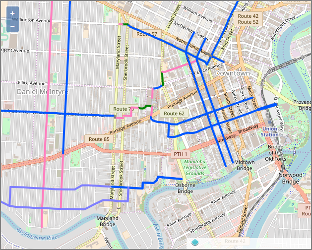
St. Matthews Ave – U of W Connection
In the Pedestrian and Cycling Strategies (PCS) adopted in 2015, St. Matthews Ave is identified as one of the network spines of the proposed bike network, providing an all ages and abilities cycling route on pathways and protected bike lanes from the Sturgeon Creek Pathway all the way to Maryland St. From there, the intent of the PCS is to provide a mix of pathways and on road routes along low volume residential streets to complete the connection to the U of W Campus.
It’s likely that this connection will require a couple of property acquisitions as well as signalized crossings of Maryland St and Sherbrook St.
Spence-Qu’Appelle Bikeway
The northern connection to the U of W in the Pedestrian and Cycling Strategies (PCS) is through Qu’Appelle Ave and Balmoral St. One drawback to Balmoral St as a connection through the U of W is that if does not provide access to the planned St. Matthews cycling spine. A second drawback is that there seems to be little political will to remove travel lanes on Balmoral St to provide the planned protected bike lanes.
The suggested route that follows avoids any on-road bikeways along Balmoral St and provides the needed connection between Spence St and Qu’Appelle Ave, with a recommendation to treat Qu’Appelle Ave as a Neighbourhood Greenway instead of a protected bike lane. Traffic volumes on Qu’Appelle are low enough that a neighbourhood greenway treatment that allows for mixing of motorized traffic with people on bikes would meet the needs of an all ages and abilities cycling route.
Ellice Segment- Spence to Balmoral
East bound bicycle traffic would be accommodated between Spence St and Balmoral St by combining the following infrastructure:
- Adding a raised bicycle lane on the south side of Ellice between Spence and the driveway in front of the University (there is space available).
- Providing cyclists with a connection from the driveway in front of the U of W to the northbound bus lane leading out of the Balmoral Transit Station.
- Adding bike lanes and a bike box to the north end of the bus lane.
- Reprogramming of the traffic signal to ensure that there is a protected phase for cyclists connecting diagonally across the intersection.
- A redesign of the traffic island and merge lane on the northeast corner of the Ellice/Balmoral intersection that would:
- Reduce the speed of vehicles turning off Ellice onto Balmoral
- Add a two way bike path across the traffic island.
- Provide a raised crossing for pedestrians and cyclists coming off of the traffic island
- Add stop control to protected cyclists and pedestrians crossing the merge lane.

There is room to add a raised bike lane on Ellice Ave just east of Spence St.
West bound cyclists could be accommodated by combining the following infrastructure:
- A bike box and bike signal using a leading bicycle interval that would permit a cyclist to cross Balmoral and reach the laneway on the north side of Ellice prior to westbound motorized traffic. Alternatively, cyclists may choose to take the left lane on Ellice and make a vehicular turn onto Spence. The bike box accommodates both options. There is already space against the traffic island for the bike lane leading into the bike box (short bike lanes such as this are often referred to as pocket bike lanes).
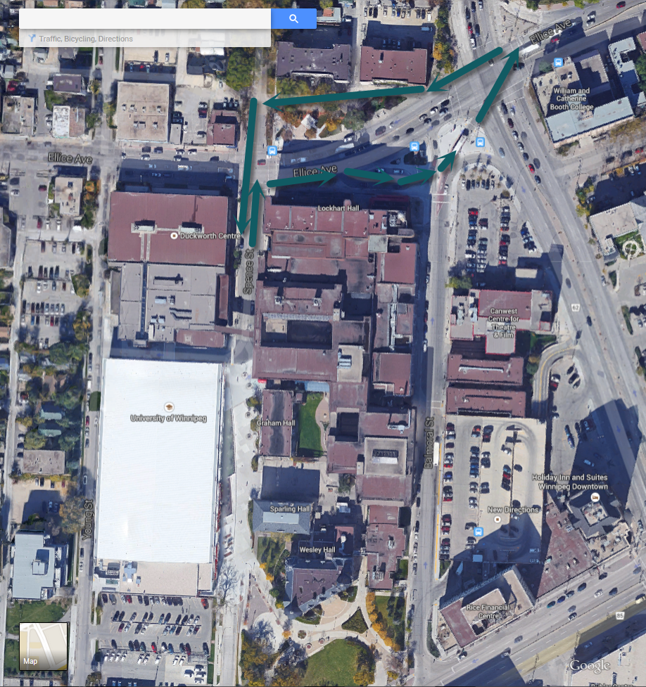
Balmoral Segment – Ellice to Qu’Appelle
Once across the Ellice/Balmoral intersection, cyclists could be accommodated by building a two way bike path on the east side of Balmoral between Ellice and Qu’Appelle. There is adequate space available for such a pathway. The cycling strategy calls for protected bike lanes on Balmoral. If this path is followed, there would be no need for this pathway as cyclists would make used of the protected bike lanes on Balmoral.
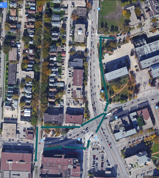
East of Balmoral
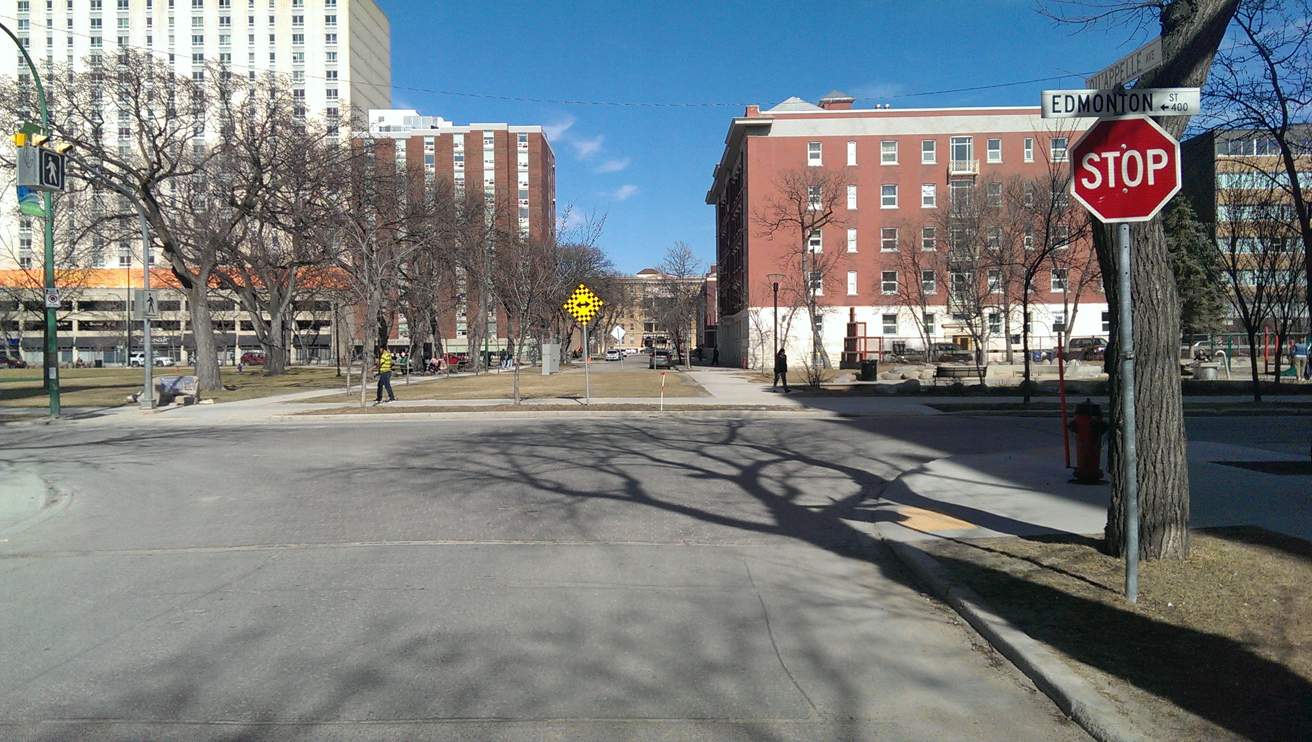
East of Balmoral, Qu’Appelle would function as a neighbourhood greenway with mixed traffic. A pathway could be built through Central Park to connect between Edmonton and Carlton, which have existing painted bike lanes that are scheduled to be converted into protected bike lanes as a short term goal of the cycling strategy. There would be a need to improve the intersection treatments at Kennedy, Edmonton, Carlton and Hargrave utilizing curb bump-outs and traffic signals where traffic demands. These changes would benefit pedestrian and bicycle users.
More Information
Downtown Bike Lane System and Street Improvements (City of Winnipeg)
Complete the Ruby/Banning Neighbourhood Greenway
Ruby and Banning Streets have the potential to be an important part of the City of Winnipeg’s bicycle network, with direct, low stress access to a community centre, multiple commercial nodes and several schools in an area of the city that has been recognized as having a high potential to attract cyclists.
In order to reach that potential, the city needs to improve the safety and convenience people experience as they walk or bike along these streets. In particular, intersections along Ruby and Banning need improvements to ensure that pedestrians and cyclists on Ruby and Banning corridor encounter crossings that are appropriate to their comfort level and the level of traffic that they are facing.
The city has completed a design study for conversion of Ruby/Banning into a Neighbourhood Greenway. All treatments have considerations for impacts on vehicle, pedestrian and bicycle traffic. The recommended design was determined based on treatments that were ranked highest through public input in terms of cycling comfort and safety, and based on technical analysis.
View the recommended design.
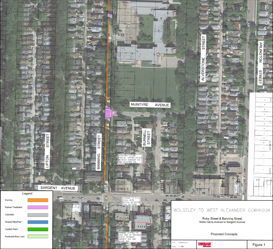
Design features for the corridor, where cycling will continue to go both ways throughout:
- Palmertson Avenue to Westminster Avenue will remain the same, with the addition of raised intersections at Wolseley and Westminster avenues.
- Westminster Avenue to Preston Avenue will be one-way northbound with parking on the east side of the street.
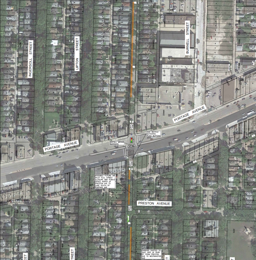
- Preston Avenue to Portage Avenue will remain the same.
- Median barriers will be installed at the Portage Avenue intersection, which will prevent left turns out of, and in to, Ruby Street and Banning Street. Through movements along Ruby Street – Banning Street will also be prevented. Pedestrian/bicycle activated push buttons will also be added.
- Portage Avenue to Einarson Avenue remains the same with a raised intersection at Einarson Avenue. The four-way stop will change to a two-way stop for the cross streets, allowing north/south traffic to flow.
- Einarson Avenue to St. Matthews Avenue will have a raised crosswalk by Greenway School.
- The intersection at St. Matthews Avenue will have right in/right out islands and be upgraded to a half signal with pedestrian/bicycle activated push buttons.
- St. Matthews Avenue to Ellice Avenue will remain the same.
- The intersection at Ellice Avenue will add pedestrian/bicycle activated push buttons.
- Ellice Avenue to Sargent Avenue will be one-way northbound with parking and loading on the east side of the street. There will be two raised crosswalks at General Wolfe School and the egress at Sargent Avenue will be right turn only.
- The intersection at Sargent Avenue will be upgraded to a full signal with pedestrian/bicycle activated push buttons.
- Sargent Avenue to Wellington Avenue will have a raised intersection at McIntyre Avenue, and a raised crosswalk at Daniel McIntyre Collegiate.
- The intersection at Wellington Avenue will be upgraded to a full signal with pedestrian/bicycle activated push buttons.
- Wellington Avenue to the back lane before Notre Dame Avenue will be one-way northbound with parking on the east side of the street. Past the back lane the parking will continue on the east side of the street, while the street will remain two-way.
Next Steps and Future Considerations
The City will review the project to determine how it fits with other City priorities and future budget considerations. Funding could come from the Local Street Renewals Program, or from the Pedestrian and Cycling Program.
Requested Candidate Commitment:
- Commit to providing funding for the Ruby/Banning Neigbourhood Greenway during your term in office.
More Information
- Wolseley to West Alexander Corridor Study (City of Winnipeg)
- Ruby/Banning Neighbourhood Greenway Recommendations (Bike Winnipeg, 2015)
Wolseley/Westminster/Balmoral/Granite Bikeway
As part of the 2018 Pedestrian and Cycling Program Action Plan, the city awarded a contract for the Study and Design of the Wolseley to Downtown Corridor in June of 2018.
This study will develop an all ages and abilities pedestrian and cycling connection from the Wolseley neighbourhood to the Downtown. The resulting design will connect:
- to the Omand Park path at Raglan Road/Wolseley Avenue at the west;
- east/west through Wolseley Avenue/Westminster Avenue, Balmoral Street, and Granite Way; and
- to the half-signal at Osborne Street at the east.
The Wolseley to Downtown Corridor Study will develop plans for walking and cycling improvements needed for an all ages and abilities walking and cycling corridor from Omand’s Park to the Walk/Bike Crossing at the intersection of Osborne and Assiniboine/Granite Way.
Goals of this project are to balance the needs of stakeholders and transportation system users to improve travel choices, accessibility and connectivity within the Wolseley neighbourhood and to the Downtown. The developed pedestrian and cycling corridor design should:
- allow people of all ages and abilities to safely walk or bike east/west along the corridor from the Wolseley neighbourhood to downtown/future potential Osborne to Downtown Walk Bike Bridge;
- provide infrastructure that will support, encourage and increase the number of students walking or biking to school; and
- start and end at logical and safe locations such that new gaps in the network are not created.
School Travel Planning will be incorporated into the planning process for the Wolseley to Downtown Walk/Bike Corridor, however the creation of School Travel Plans is not included in the contract.
Requested Candidate Commitments
- Commit to Construction of the Recommended Wolseley to Downtown Pedestrian/Cycling Corridor Design by the end of the next term of Council.
More Information
2018 Pedestrian and Cycling Program Action Plan (City of Winnipeg)
St. Matthews Protected Bike Lanes
As a major east/west spine in the City of Winnipeg’s planned bike network, cycling facilities on St. Matthews Avenue will need to be designed for all ages and abilities. That’s why the Pedestrian and Cycling Strategies have identified the need for protected bike lanes on St. Matthews Ave.
Current cycling facilities along St. Matthews are limited to sharrows and narrow painted bike lanes, which alternate every 3 or 4 blocks. It’s a confusing treatment, and does not make the best use of the available roadway.
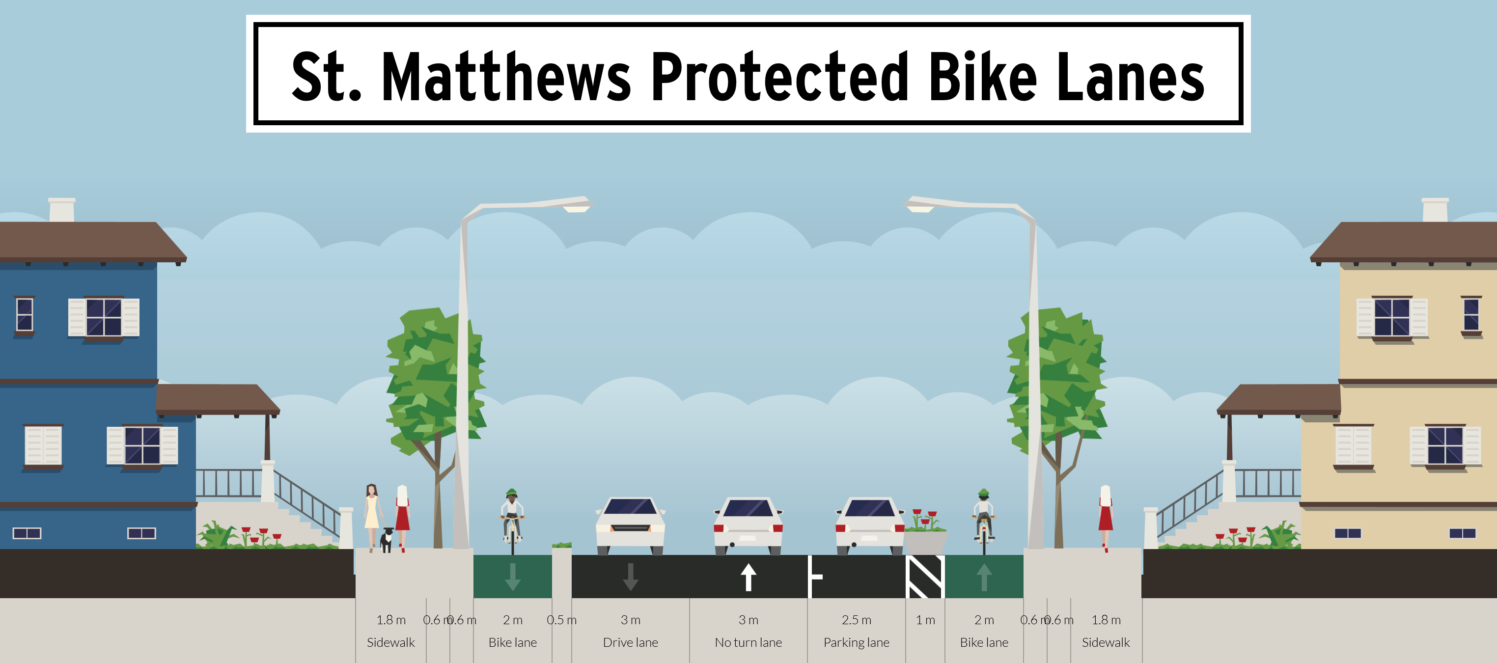
Protected bike lanes could be fit onto St. Matthews Ave if parking were limited to one side of the roadway,
As parking demand along St. Matthews is modest, it should be possible to add protected (or raised) by limiting parking to one side of St. Matthews.This could be combined with curb bump-outs to provide better sight lines at intersections and shorten crossing distances for people crossing St. Matthews. By alternating which side of the road parking is allowed on, this treatment would also provide natural traffic calming.
Future Rehabilitation Work Must Include Protected Bike Lanes
Recent rehabilitation work on St. Matthews Ave (near Minto) failed to upgrade the existing painted bike lanes and sharrows to the much more user friendly protected bike lanes. That was a lost opportunity. All candidates in Daniel McIntyre ans St. James should commit to:
- Commit to the installation of protected bike lanes in any rehabilitation work on St. Matthews Ave between Arlington St. and Empress St.
- Commit to a study of potential cycling improvements between Maryland St and Arlington Street prior to any rehabilitation work on St. Matthews move forward on this stretch of St. Matthews. Options would include:
- Conventional painted bike lanes
- Advisory Bike Lanes
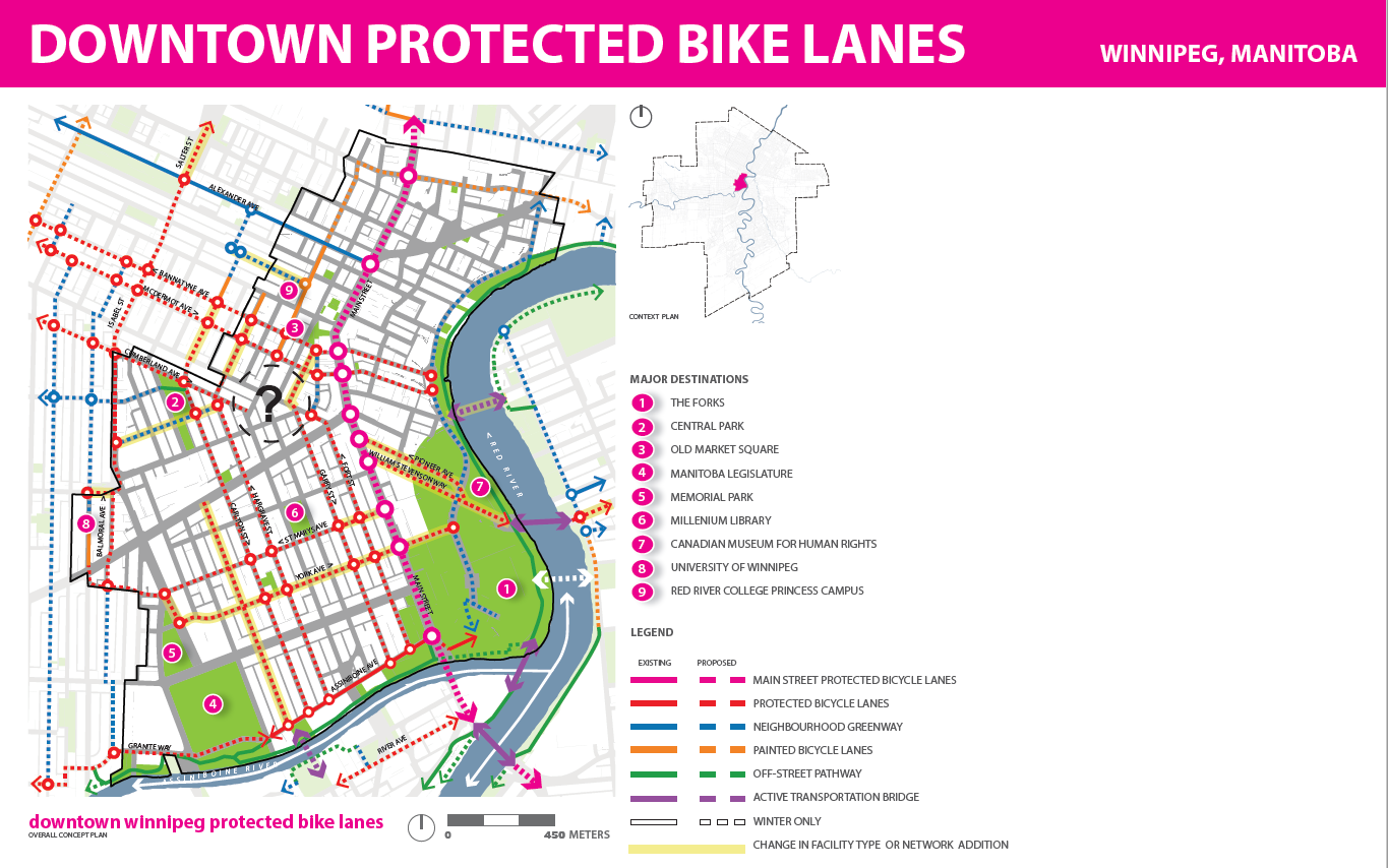
Complete the Downtown Protected Bike Lane Network
Downtown Separated Bicycle Lane Network
Despite having been identified as a short-term “quick win” that should be prioritized in the next one or two years.[1], construction of the city’s down town separated bike lane network is finally starting to take shape with the completion of the McDermot/Bannatyne Avenue protected bike lanes in 2018 (plus segments of the Princess, Notre Dame, Hargrave, and Carlton Protected Bike Lanes) and the expected completion of the Garry Street protected bike lanes in 2019.
Still, full build-out of the downtown separated bicycle lane network is not within the 3-year planning horizon of the 2018 Pedestrian and Cycling Program Action Plan, and even then the planned network will not provide the level of connectivity recommended in the Downtown by the Pedestrian and Cycling Strategies (400m grid width).[2]
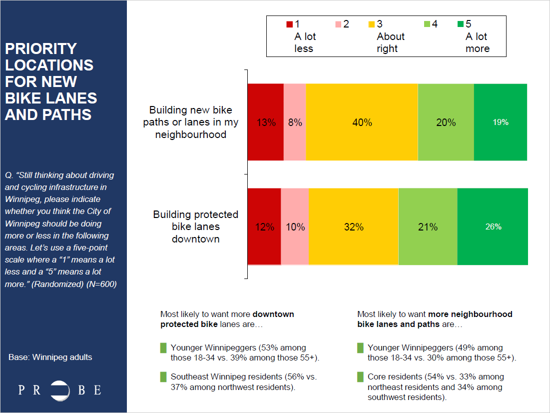
A June 2018 Probe Research poll found substantial support for installation of protected bike lanes in the downtown. When asked if they think the City of Winnipeg should be building more or less protected bike lanes in the downtown, almost half (47 per cent) of respondents said the city should be building more protected bike lanes downtown.
We urge the city to fast track development of the downtown separated bicycle lane network by committing to plan for all remaining segments (and proposed additions along St. Mary & York) in 2019, and by installing adjustable separated bike lanes in 2019/2020 to be followed with permanent installations as the roadways undergo planned renewals.
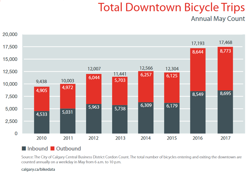
Case Study
In 2015, the City of Calgary fast tracked the planning and installation of a five street downtown protected bike lane network using cheaply installed adjustable barriers (similar to those being piloted in Winnipeg right now).
Results:
- Ridership has tripled along the network.
- Bicycle trips into and out of downtown increased by 40% between the 2015 and 2016.
- Perception of safety of people cycling increased from 68% to 91%.
- People are going one or two blocks out of their way to use the cycle tracks.
- The highest ridership occurs where cycle track routes are closer together.
Footnotes
[1] Page 312, Pedestrian and Cycling Strategies, City of Winnipeg, 2015
[2] Page 135, Pedestrian and Cycling Strategies, City of Winnipeg, 2015
Empress Street Pathway Connections
A pathway along the east side of Empress Street will be built in 2019 as part of the Empress Street and Overpass Reconstruction and Rehabilitation Project, extending from St. Matthews Avenue in the north south over the Empress Street Overpass to the North Assiniboine Parkway. Future plans call for the pathway to be extended north all the way to Saskatchewan Avenue, where it will connect to pathways along Saskatchewan Avenue and Sherwin Road to provide a connection to Red River College’s Notre Dame Campus.
What’s missing from the planning to date is a way to connect from this planned Empress Street pathway north to the Alexander-Pacific-Elgin Neigbhourhood Greenway and the Northwest Hydro Corridor Greenway, and northwest towards the Keewatin Street Pathway. Work to extend the Keewatin Pathway south to Gallagher Avenue is scheduled to take place in 2019 (see our recommendations and rationale to include a path on the east side of Keewatin along with the planned pathway on the west side of Keewatin). Work on the Northwest Hydro Corridor Greenway should begin in 2019 (although an extension across the CPR Mainline may need to wait for a rehabilitation of the McPhillips Street Underpass).
An All Ages & Abilities Connection from Empress St to Alexander Ave
An all ages and abilities connection from Empress St to Alexander Avenue is possible using a mix of neighbourhood greenways along low volume residential streets in the Weston Neighbourhood, pathways along Saksatchewan Ave, Midland St, and the BNSF rail line, and a short two way protected bike lane segment along Notre Dame Ave between Dublin Ave and Spruce St. If implemented, the route would provide users with safe crossings of Notre Dame Ave, Weston St., McPhillips St, and Logan Ave at existing traffic signals or pedestrian corridors. Assuming future plans to extend the Northwest Hydro Corridor will include a safe crossing of Logan Ave, only the Elgin @ Keewatin crossing would require crossing improvements (push-button activation for the pedestrian corridor for people on bikes).
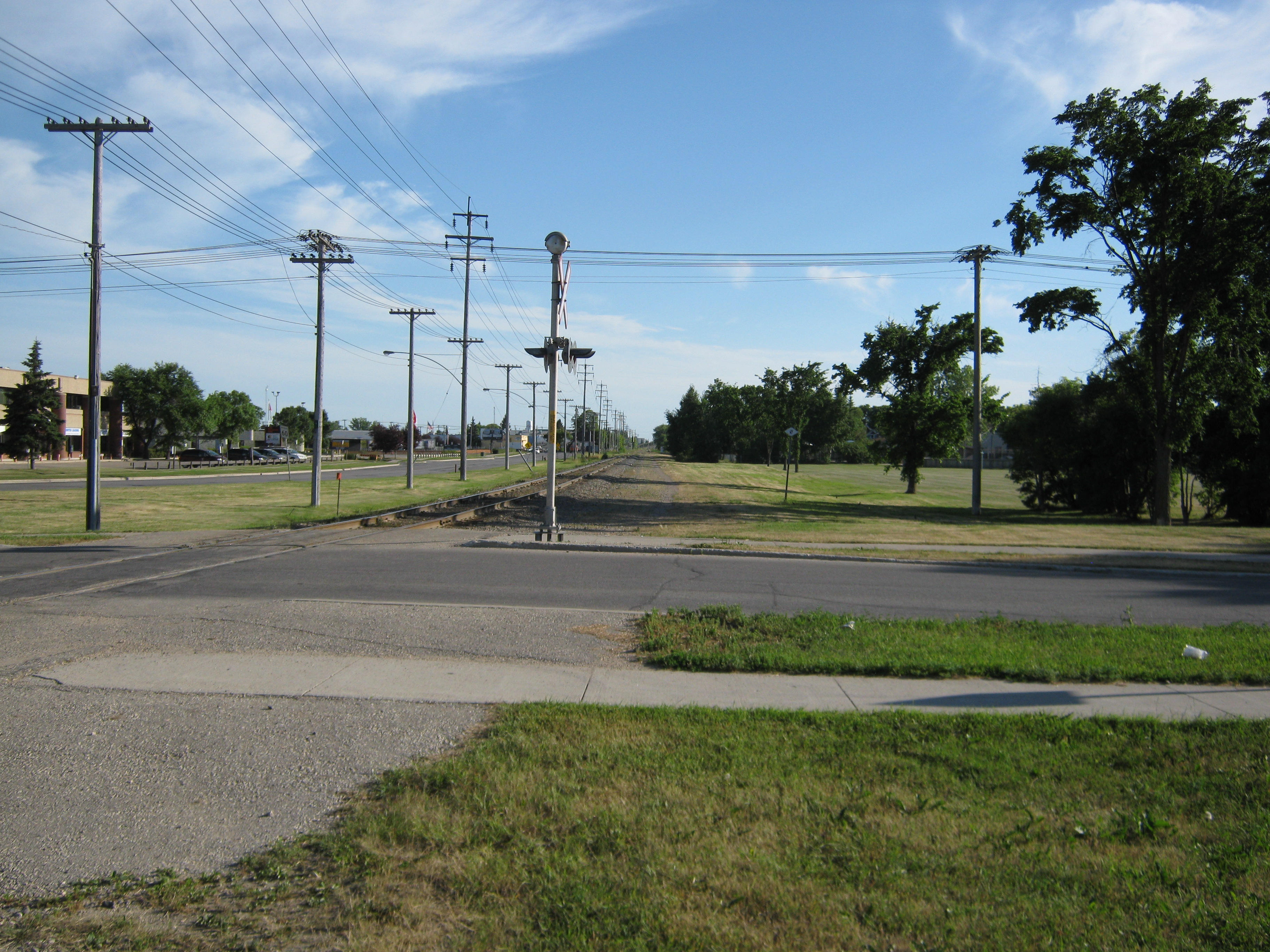
Looking south from Alexander Ave towards Notre Dame Ave, with Pascoe Park to the right.
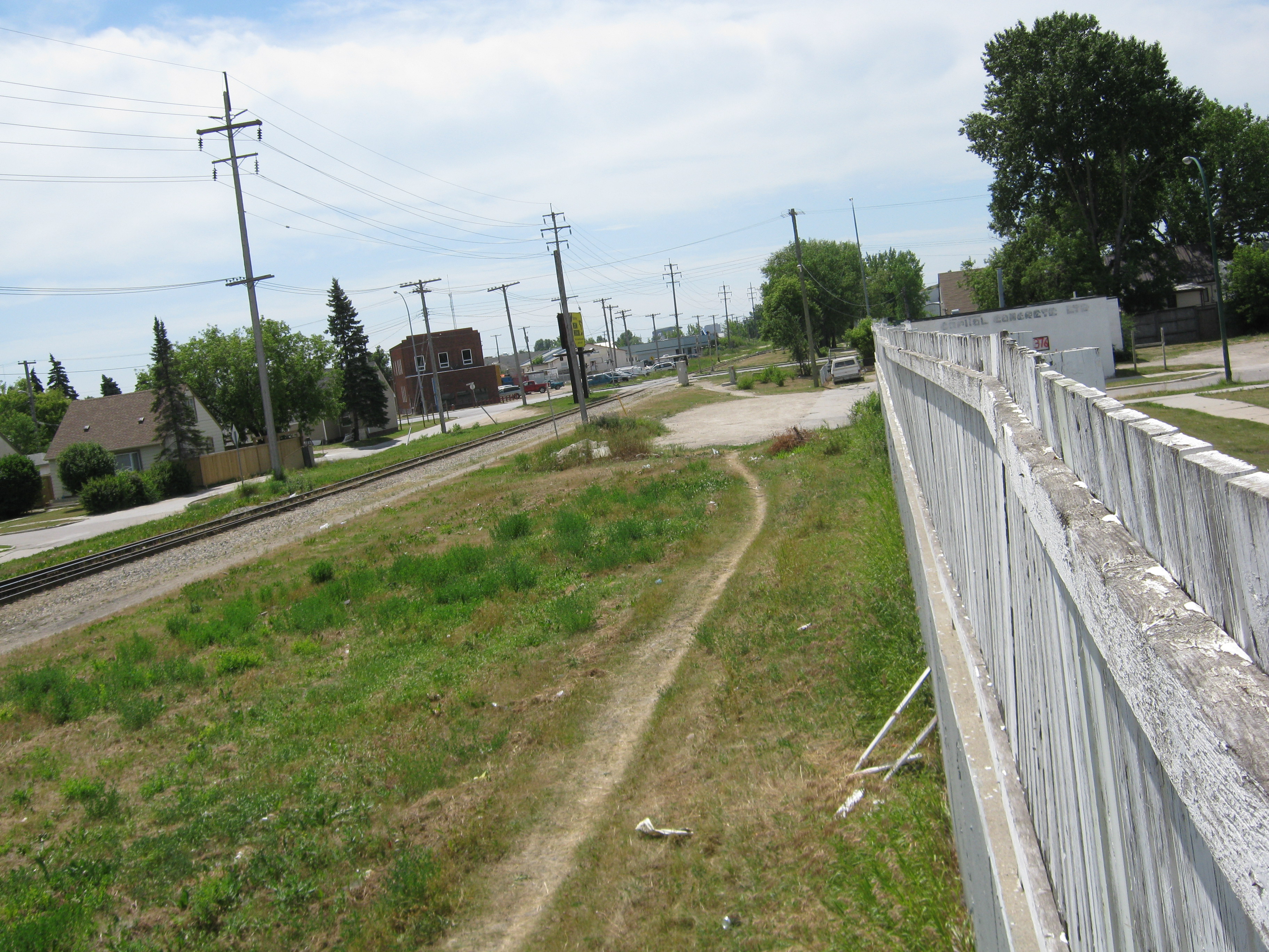
Looking north from Winnipeg Ave towards Alexander Ave and Pascoe Park. Note the well used pathway.
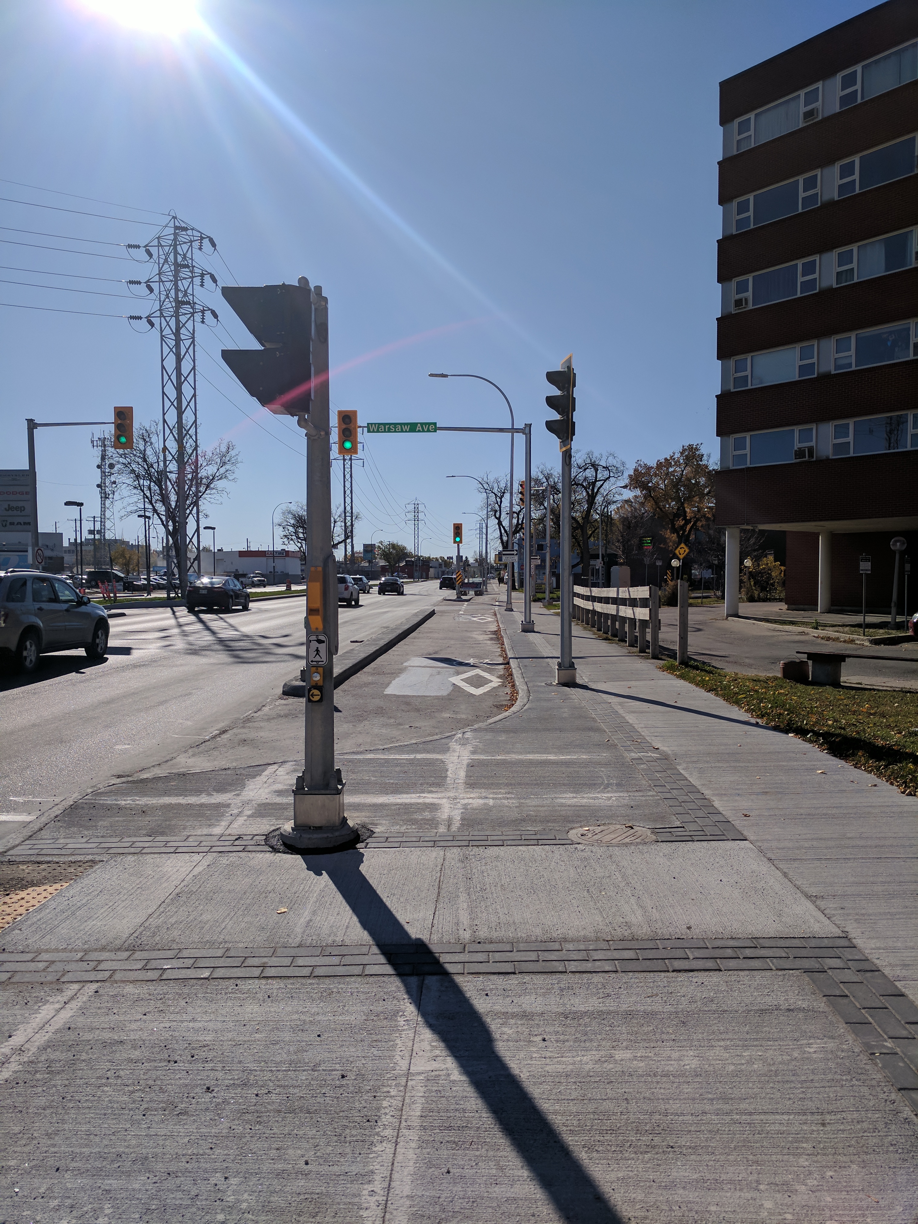
This two way bike lane on Pembina Highway could serve as a model for a two-way protected bike lane on Notre Dame Ave connecting Dublin Ave to Flint St and Spruce St.
This two way bike lane on Pembina Highway could serve as a model for a two-way protected bike lane on Notre Dame Ave connecting Dublin Ave to Flint St and Spruce St.
Replacement of the Omand’s Creek Bridge on Saskatchewan Ave in 2016 included provision for cycling facilities on Empress Street and a 2.5m wide sidewalk across Omand’s Creek that could accommodate a shared use pathway connecting Empress Street to a potential pathway along Saskatchewan Avenue leading to a Midland St pathway.
Include Connections to Alexander Ave in Planning for Empress St Pathway
We are asking that preliminary design of our proposed connections from the intersection of Empress St and Saskatchewan Ave to the intersection of Alexander Ave with Weston St, Lincoln and Pacific Avenues with Weston St, and improvements to the crossing of Keewatin St at Elgin Ave be added to the scope of the Preliminary Design Project for Rehabilitation of Empress Street between Saskatchewan Ave and St. Mathews Ave (set for 2023).
As there are no existing plans in the Pedestrian and Cycling Strategies for a crossing of the BNSF line to connect to planned Wellington Avenue Protected Bike Lanes (which serve as a spine in the bicycle network and connect through to Cumberland Avenue and the Downtown Protected Bike Lanes Network), we are also recommending that planning for the Empress St Pathway include a connection to the planned Clifton Neighbourhood Greenway via Notre Dame Ave and Spruce St.
More Information
- Northwest Hydro Corridor Greenway Backgrounder
- Keewatin Street Pathway Backgrounder
- Empress Street and Overpass Reconstruction and Rehabilitation Project (City of Winnipeg)
- 2018 Pedestrian and Cycling Program Action Plan (City of Winnipeg)
Ward Boundaries: Legal Description Maps
Candidates: Josh Brandon Cindy Gilroy Sarowar Miah